Fishing Grounds of the Gulf of Maine. 1929
BAY OF FUNDY
At the different seasons of the year the entire Bay of Fundy is a fishing ground for sardines and large herring; and while these are of somewhat less importance in recent years than formerly, the principal fisheries of this region still center around the herring industries--the supplying of the canning factories with the small herring used as sardines and the taking of large herring for food and bait. The sardine industry of the State of Maine is largely concentrated in the district about and including Eastport and Lubec, where about 30 of the 59 factories and 16 of the 43 operating firms are located; so that, while the herring catches of recent years have fallen much short of their former proportions, they still show imposing figures.
In the past much of the catch was taken in St. Andrews (Passamaquoddy) Bay and along the north shore of the Bay of Fundy to Lepreau Bay and Point. Lepreau. Of late years virtually no herring have been taken in these waters, in which the herring schools that arrive in October were accustomed to remain until spring. Of past fishing in this locality Capt. Sumner Stuart, of Lubec, says:
"The herring left St. Andrews Bay and the North Shore about 1885. There is no summer netting there now. Those waters and Lepreau Bay were formerly very productive fishing grounds, it being not unusual to take 5,000 (count ) big herrings (food fish) in a single haul. These were mainly spring and winter fishing grounds for large herring. The fish seem to have disappeared from all these grounds at about the same time.(10)
"In past years (25 to 30 years ago) small herring were driven ashore in such quantities by their enemies--squid, silver hake and dogfish--that it sometimes became necessary for the authorities at St. John to use a snowplow to cover them where they lay decaying on the beach."
From the statistics of the sardine and smoked-herring industry for the year 1924 (a year, be it noted, in which the sardine industry almost reached low--level mark for the pack) the waters of the Bay of Fundy furnished to American purchasers alone a total of herring for smoking and canning purposes amounting to 76,756,250 pounds valued to the fishermen at $957,665. This showing, poor as it is when compared with the figures of other years, by no means represents the herring fishery as an unimportant industry. There still remains to be accounted for the catch of herring of Grand Manan and the neighboring Canadian Provinces.
A new source of profit to the fishermen in this industry has been developed in the purchase of herring scales by firms engaged in the manufacture of artificial pearls. For this purpose there were collected at Eastport and Lubec 700,000 pounds of herring scales, valued at $39,000; and a further amount was taken at Grand Manan of 140,000 pounds, valued at $7,000. With other entrants already in the field, this branch of the industry bids fair to grow to still greater importance.
An estimate of the number of weirs in St. Andrews Bay, by Capt. Guilford Mitchell of Eastport, Me., is as follows: Canadian: 1921: 126 weirs 1923: 40 weirs Calais to Eastport: 1921: 35 weirs; 1923: 7 weirs Total number in operation, 1923, Canadian, about 300; American less than 130.
(Footnote 7) This, the most striking cape of the Atlantic coast line, made a very prominent landmark for all the early ocean voyagers approaching it, and all were greatly impressed by it, whether they came from the south and fought their way through its shoals to eastward, or, coming from the north, found themselves caught in the deep pocket which it makes with Cape Cod Bay.
The Spaniard Gomez (1525) gave it the name "Cabo de do Aricifes" cape of the reefs, referring to the dangerous shoals to the eastward. The Frenchmen Champlain and Du Monts named it "Cape Blanc", and the Dutch pilots, also noting its sandy cliffs, called it Witte Hoeck. The English mariners at first accepted his last name of White Cape, but the English Captain Anthony Gosnold, the first to make a direct passage to the waters of the Gulf of Maine from Europe, although at first he called it "Shoal Hope", soon changed this, because of the success of his fishing, to "Cape Cod", which title, commonplace though it be, has been the name to endure despite Prince Charles's attempt to change it to Cape James in honor of his father.)
(Footnote 8) Cape Sable, at the southern end of Nova Scotia, has held this title from very old times. It is so indicated on a Portuguese map of the middle of the sixteenth century.
(Footnote 9) It [Fundy] was not clearly indicated by Verrazano (1524) nor in the report of Gomez (1525), who probably saw something of its entrance but fog or other unfavorable circumstances may have prevented him from observing it more accurately, but we find in the first old Spanish maps, in the latitude where it ought to be, names like these:
Rio hondo or 'fondo' (a deep river) or Bahia Hondo (a deep bay), or Golfo (a gulf) once, also 'La Bahia de la ensenada', the bay of the deep inlet.
Doctor Kohl, here quoted further says "On the maps of the seventeenth and early part of the eighteenth century, especially, it is written Bay of Funda. I believe that this name grew out from and is a revival of, the old Spanish name 'Bahia fondo'".
(Footnote 10) It is gratifying to announce that the winter of 1925-26 saw a large run of herring on this ground, where for a number of years past there has been virtually no fishing for this species.
North Shore and coast of Nova Scotia. Along the North Shore and from Yarmouth to Cape Sable, over a hard bottom, cod abound. The western shore of Nova Scotia is virtually all fishing ground for cod, haddock, hake, and cusk, but trawling is somewhat handicapped here by strong tides and rocky bottom, these combining to destroy much gear. Halibut are somewhat unusual on this western shore except about the mouth of the Bay of Fundy, but in summer these fish are occasionally found close inshore along the southwest coast, going somewhat beyond Digby to the northward. Haddocking is quite an important industry off Yarmouth, Nova Scotia, during the winter, the sets being of rather short duration and made at the slack of the tide at high water. This practice is made necessary by the heavy tidal currents on these grounds.
The whole western coast of Nova Scotia is herring ground at some season of the year. "Drifting" for herring was formerly a considerable industry from Digby to Briers Island, but in these last few years it has not been important, although the year 1927 had a very good run of large food fish. This western coast is also an important fishing area for lobster men.
Swordfishing in the Bay of Fundy was formerly profitable in September, although these fish were never so numerous here as upon the outer shore of Nova Scotia.
St. Marys Bay is a summer herring ground. Good haddocking may be had here, also, from April 15 to October 15, with the period from the opening of the fishing in April up to July 15 the best of it.
The mackerel fishery of the Bay of Fundy seems of comparatively small importance in these latter years. The local fishermen say that the fish can not stem the tides of these waters! The abundance of small herring should be an inducement sufficient to bring them here. Apparently these fish pass straight inshore northwesterly and reach the coast of Maine. A considerable amount of this species is taken by traps and by netting in St. Marys Bay and in the general vicinity of Yarmouth, Nova Scotia, as at Cranberry Head, Burns Point. Beaver River, Woods Harbor, and at various other points between Yarmouth and Cape Sable; but the inner waters of the Bay of Fundy show very slim catches when compared with the great amount taken on the outer shores of Nova Scotia in a normal mackerel season. It has been 32 years, it is said, since any number of mackerel have been "hooked" in St. Mary's Bay.
Lurcher Shoal. This lies WSW, from Cape St, Mary 19 miles and WNW, from Cape Fourchu, distant 13 miles, it is an irregularly shaped piece of bottom, a rocky ground, about 5 miles long, north and south, by 3 miles wide, There are a number of "nubbles" arising to 5, 7, and 9 fathom depths--with a spot reported as having only 12 feet of water over it-- rising from the average depths over the rest of the shoal of from 13 to 15 fathoms. Over this generally rocky bottom are scattered patches of gravel and of shells, Depths about the shoal are from 30 to 50 fathoms over a bottom consisting mostly of stones, Tide rips are very heavy here, The seasons and species found here are as on Trinity: cod, haddock, pollock, and herring, it is a good lobster ground.
Trinity Shoal. This shoal, 14 miles N, by W, from Cape Fourchu and 7 ˝ miles SW, from Cape St Mary, with a rocky bottom upon it and over an indefinite area about it, is perhaps 3 miles long, NE and SW, by some 2 miles wide. Near the center is a rock, uncovered at low water, but over the greater part of the shoal there are depths of from 6 to 10 fathoms, with an average of from 12 to 16 fathoms over the sandy and stony ground about it. There is a strong tide rip here on the eastern and northeastern part known as Flood Tide Eddy, where is good fishing by hand line for pollock in September and October. Cod and haddock are taken here in small amounts by trawling. It is a herring ground also, and there is a lobster ground on the shoal and all about it.
A cod ground extends offshore SW from Briers Island, beginning about 5 miles out from the island and extending to about 18 miles from the land. Its width is about 4 miles. Depths over this area are from 40 to 60 fathoms over a hard, shelly bottom. Cod are taken here in from 30 to 44 fathoms on the shoal ground running from 5 miles from Gull Rock and the South-West Ledges down to the Lurcher Shoal, a distance of about 22 miles. Between these points fishing is done mostly by hand-lining "at a drift." Cod are taken over the ledges in 5 fathoms of water and thence out to 60 fathoms about them from August to November. Pollock are taken by the same method. The best season is August. September, and October. This is a good lobster ground.
Northwest Ledge. Lies about 3 3/4 miles northwesterly from Briers Island. This is a piece of rocky bottom about 2 miles long by something less than 1 mile wide with depths of from 2 to 10 fathoms over the ledge and soundings of 12 to 30 fathoms on the gravelly ground about it. Cod are found here in good number from September to November, inclusive, and are taken by hand-lining. Pollock also are taken here in summer, "drailing" by hand line.
A narrow piece of rocky ground with somewhat greater depths connects this with Batsons Shoal, some 5 miles SW., the two thus making what is virtually one piece of ground. Depths on Batsons Shoal are rather less than on Northwest Ledge, but the methods of fishing, the species taken, and the seasons of their abundance are the same on both. The bottom all about these two grounds is rocky, with from 20 to 40 fathoms inside of them, but this deepens rapidly to 100 fathoms over rocks and coarse gravel outside of them to W. and NW.
West-Northwest Rips and the Flat Ground,--These lie WNW from Briers Island, extending offshore about 18 miles. On the eastern end of this area, two parallel shoals, about 1 ˝ miles across and having 50-fathom depths between them, rise from the 100-fathom depths of water over the muddy ground around them to reach 15 fathoms on the landward end of the rips, deepening to 35 fathoms off the western part, where the two ridges come together at about 9 miles distance from Briers Island, to carry on to the westward over the Flat Ground, which extends to a distance of about 18 miles from the island.
This Flat Ground, deepening gradually westward, averages to have 50 fathoms of water over a level, gravelly, and rocky bottom, to pitch down suddenly, as do all other slopes of this piece of ground, to the 100-fathom depth, which prevails on all sides of The Rips. Currents are very strong here, as elsewhere in these waters, so that trawls are set only on the slack of the tides, beginning about one hour before and remaining down until about one hour after these periods. Formerly this was a good ground for the taking of large herring. In these days The Rips furnish good cod and haddock fishing for the entire year, with hake abundant at all times on the mud about them. In fact; virtually all the ground from this point south to the Lurcher Shoal furnishes good fishing for these species.
Boars Head Ground (also called Inner Ground). This parallels the coast about 4 miles N. by NW from the Head, at Petit Passage, into St. Marys Bay. This ground is about 4 miles long by 3 miles wide, having depths from 55 to 65 fathoms over a hard bottom of broken ground. Cod are most numerous here from April to July, inclusive; haddock from July to September, inclusive. Hake are found here in summer and early fall, principally on the muddy ground between this and the next fishing ground--the Outer Ground.
Outer Ground. This is about 3 miles long by 2 miles wide, lies about 9 miles out from the main on the same bearing as the Inner Ground, and is visited by the same species, their periods of abundance upon this piece of bottom being the same as on the former ground. Virtually all taking of ground fish on these grounds is done by hand-lining, though the practice of trawl fishing has come more and more into use in recent years.
Head and Horns. A shoal of 68 fathoms, about 2 miles long in a NNE and SSW direction by 1 mile wide, lies due north from the Boars Head of Long Island. Here is a hard bottom where good cod fishing is had during the spring and summer. Hand-lining from the bottom is carried on in summer for pollock. Haddock are few here, these appearing mostly in the summer. Depths about the ground average 80 fathoms over mud and stones.
Sandy Cove Ground. Lies offshore NNE about 7 miles from West Sandy Cove. It has from 40 to 50 fathoms of water over a sandy bottom, lying parallel with the coast, about 4 miles long by 2 miles wide. Cod are abundant on this ground from May to July, hake coming somewhat later. As were most of the grounds of this vicinity, this ground was mainly a hand-line spot, but in recent years fishing here has been done mostly by the trawl method.
Inner Sandy Cove Grounds. About 2 miles NNW. from West Sandy Cove. These are 3 miles long NNE. and SSW. by ˝ mile wide. Both hand-lining and trawling methods of fishing are in use here, but the trawl is fast displacing the older gear. Depths are about 35 fathoms over a sandy bottom and 50 fathoms all about it. Species and their seasons of abundance are as on the Outer Sandy Cove Ground. Almost anywhere between Spencer Island and Cape Split there is good haddock fishing in June and July and cod fishing in May and June. Depths are from 16 to 40 fathoms: the bottom is generally stony, with considerable areas of gravel. The fishing is done principally by trawling, rather short "sets" being made. Off Cape Split are considerable whirlpools, which, with spring tides, are very dangerous. These sometimes run 9 knots an hour.
Spencer Island. Almost anywhere between Spencer Island and Cape Split there is good haddock fishing in June and July and cod fishing in May and June. Depths are from 16 to 40 fathoms: the bottom is generally stony, with considerable areas of gravel. The fishing is done principally by trawling, rather short "sets" being made. Off Cape Split are considerable whirlpools, which, with spring tides, are very dangerous. These sometimes run 9 knots an hour.
Isle au Haute.Lies far up within the bay 9 miles W. ˝ S. from Cape Chignecto. All about this island are good summer haddock grounds with fair cod fishing. The latter are taken by trawling principally. Depths about the island are from 9 to 14 fathoms, deepening offshore to 35, the average depths being 22 to 27 fathoms. North of the island the bottom is generally sandy; elsewhere much of the ground is rocky or stony, with here and there a small patch of gravelly ground. To the S. of this ground, toward the Nova Scotia shore and to within 2 miles of the coast, the bottom is mainly muddy and of little account as a fishing ground. Tides are very heavy on all the inner grounds of the Bay of Fundy.
Quaco Ledges. This ground lies about 10 miles SE, from Quaco Head and is out at low tide, the water about the ledges having depths from 14 to 30 fathoms over a bottom of stones and gravel, There is a heavy tide rip over these ledges when covered, These furnish good pollock fishing in the summer months, and cod fishing is carried on here by hand-lining from May to July.
Salmon Netting Ground. A salmon-netting ground lies off about the Mouth Harbour and St, John Harbour, where these fish are netted, for the most part during June and July, when they are en route to the St, John River, where are their spawning grounds.
Ingalls Shoal. This is the name given by some of the fishermen of the vicinity to a shoal lying about midway between Digby, Nova Scotia, and Point Lepreau, New Brunswick. This ground is about 9 miles long. NE. and SW., by about 5 miles wide. It lies about 22 miles NW. from Digby and 18 or 20 miles from Point Lepreau. The depths are from 35 fathoms on the shoalest area (where is a piece of ground some 4 miles long by 1 mile wide near the center of the bank, lying in a NE. and SW. direction), the bottom sloping away from this on all sides to 47 or even 55 fathoms in a few places. The bottom is mostly of sand and gravel or of small stones over much of the ground except for the shoal parts, where it is mainly rocky. This piece of fishing ground furnishes good cod fishing in June, July, and August, which formerly was carried on by hand-lining but now, as elsewhere in the bay, is more and more becoming a trawl fishery. Haddock and pollock also are taken here in fair amounts.
Mussel Shoal Ground. This is a mussel-covered bottom lying 8 miles ESE. from the Eastern Wolf and 9 miles from Point Lepreau. It runs in an E. and W. direction and is about 2 miles long by 1 mile wide. Depths are from 40 to 50 fathoms. This is a mussel and scallop bed, where large cod are usually in abundance in winter. Pollock are plenty here in June, and hake are here and in the surrounding Hake Ground in all the summer months.
The Wolves. These make a group of small islands lying N. ˝ E. from Grand Manan, distant 8 or 10 miles. On the bottom of rocks and gravel, extending about a mile from the shores of these, in depths of from 18 to 34 fathoms, small boats and small vessels take a quantity of fish by trawl and hand line. These are mainly haddock and cod grounds in May and June and pollock grounds in June and July. It is also a winter lobster ground for Canadian fishermen.
The Wolves Bank. This bank lies between The Wolves and Grand Manan, distant about 8 miles from East Quoddy Light, SE. ˝ E. Marks: The Coxcomb showing to the eastward and just touching on the western edge of Green Island: bring the heads of Grand Manan to form The Armchair, and White Horse and Simpson Island into range. This is a small-boat ground of scarcely more than 6 acres, with depths of 18 to 30 fathoms on a bottom of rocks and mud. Species and seasons are as on The Wolves. Southeast from The Wolves from 2 to 20 miles lies a piece of muddy bottom where hake are usually abundant in summer.
Campobello and vicinity. Fair quantities of haddock and cod are found between Grand Manan and the American shore in the North Channel (Grand Manan Channel) between West Quoddy Head and Grand Manan in depths of from 40 to 50 fathoms, over a bottom of rocks, mud, and sand in June, July, and August and up to September 15, while hake is the most abundant species present.
No haddock or cod are on these grounds in winter. Halibut are taken in similar numbers in the North Channel in May, June, and July. Pollock are taken on the western side of Campobello Island, near the eastern side of Indian Island, and at the mouth of the channel between Campobello and Casco Bay Island. In all these places are strong tidal eddies. Some fish are taken by seining, but most are caught by hook and line in a small-boat fishery lasting from June 1 to September 1.
All around Campobello and Deer Island and on the New Brunswick shore as far as St. John are located weirs, which furnish large quantities of herring to the factories at Eastport and Lubec.
Passamaquoddy Bay. (11) Depths here are from 10 to 24 fathoms, even 30 fathoms where the St. Croix River passes out into the sea. In general the bottom is muddy, although there are rocky patches. In most years a school of cod "strikes" here in April, the early corners being mostly of small size, but the later arrivals may reach 30, 40, or even 60 pounds. Haddock sometimes make their appearance in the bay as early as May 1, remaining through August. Hake, also, are present from June to September, but this excellent fish is held of little account by local fishermen. A considerable flounder industry is developing in these waters, the fish being taken in specially devised traps as well as by the smaller otter trawls.
Passamaquoddy Bay is also a spring netting ground for herring (food fish), and there are also many weirs in operation here each year whose catch goes to the factories of Eastport and Lubec for canning as sardines. Pollock are very abundant, and a great deal of fishing for them is carried on from June to October, both by seine and hand line. At times the pollock completely fill the many herring weirs, until, from their numbers, there is no market for them. Pollock are also abundant at the same season and are taken by the same methods in the St. Croix River, though perhaps they leave the river a month earlier in the fall.
The Mud Hake Grounds. These grounds extend about N. and S. between Campobello and The Wolves and from about West Quoddy Head to Grand Manan. Their length is about 15 to 18 miles and their width 3˝ miles. This is a summer ground much used by Canadian fishermen out of Campobello, Grand Manan, and Beaver Harbor. It is said to be the best hake grounds in this vicinity. Depths are from 45 to 60 fathoms, and fishing is done by trawls and hand lines.
There is a stretch of muddy bottom from Point Lepreau and Beaver Harbor to Grand Manan, which furnishes good hake fishing. In general, the bottom on the western side of the Bay of Fundy is muddy. Off Beaver Harbor on a mud bottom with 30 fathoms of water cod are found the year around, although this fishery is mainly carried on in the winter in small craft from Beaver Harbor and Campobello, mostly by trawling, but some hand-lining is carried on.
Beaver Harbor. There is a stretch of muddy bottom from Point Lepreau and Beaver Harbor to Grand Manan, which furnishes good hake fishing. In general, the bottom on the western side of the Bay of Fundy is muddy. Off Beaver Harbor on a mud bottom with 30 fathoms of water cod are found the year around, although this fishery is mainly carried on in the winter in small craft from Beaver Harbor and Campobello, mostly by trawling, but some hand-lining is carried on.
Grand Manan Bank. This bank is at the entrance of the Bay of Fundy, SW. ˝ S. from the southwest head of Grand Manan Island from which the northern part of the bank is 15 miles distant. From Mount Desert Rock, E. by S., it is 45 miles distant. The bank is 10 miles long and 5 miles wide, extending in a NE. and SW. direction. The bottom is mostly stones and gravel, the depths running from 24 to 45 fathoms. Soundings of 18 and 21 fathoms are found on the northeast part.
Cod (especially abundant when the June school is on the ground) and pollock are the principal fish. Haddock are not usually abundant, although sometimes they are plentiful in the fall from late September to December; hake are fairly abundant on the mud between Grand Manan Bank and the Middle Ground (in The Gully). This is a good halibut bank, the fish being in 33 to 60 fathoms in June and July; the southwest soundings and the southeast soundings are most productive always.
The best fishing season is from April to October, when the fish come to this bank to feed. In the spring the fish, other than halibut, are mostly on the southwest part, but later (July to October) the best fishing is had on the northern edge of the ground. The very best herring fishing for large herring (food fish) occurs on this bank in June and July. In general, this is a small-vessel ground fished by craft from Cutler, Eastport, Grand Manan, and, to a less extent, Yarmouth, Nova Scotia, with an occasional visit by craft from Portland and Rockland, chiefly trawlers of moderate size.
Tides run NE. in flood and SW. on the ebb and are quite strong, the flood being the heaviest. Because of these powerful currents, fishing is somewhat difficult, it being necessary to make sets at the slack of the tides, getting the gear over and traveling with the finish of the current, to take it up and come back with the tide's return.
Clarks Ground. This lies SSE. from White head 4 ˝ miles (just inside the Bulkhead) and has depths from 6 to 14 fathoms over a rocky bottom. Here are very heavy rips on the ebb tide. This is a good summer ground for pollock, cod, and halibut, and it is a good herring-netting ground in the season.
Southern Head Reef. The chain of reefs extending S from White Head Island is all good ground in summer for cod and for pollock, also, when the herring schools are on this ground. Currents are very heavy here. The ledges that make up this reef are more or less connected. Among these are Brazil Shoal, Tinker, Inner Diamond, Outer Diamond, Crawleys, Rans, Proprietor (Foul Ground), and the Old Proprietor. While virtually all this reef is pollock ground, Crawleys and Rans perhaps furnish the best fishing.
Gravelly. Lying about 5 or 6 miles SE. by S. from White Head, this piece of bottom has about 25-fathom depths over a rocky bottom. This is a cod and pollock ground in their season. While an occasional halibut is taken here in summer. Heavy tide rips occur here also.
The Soundings. Mentioned elsewhere as a herring ground, these lie outside the Bulkhead Rips 8 or 9 miles SE. from White Head. There are 30 or 40 fathoms of water here over a rock bottom, where pollock and cod are found in good number in July, August, and September, and a certain amount of halibut in summer.
Bulkhead Rips, also called The Ripplings. This is a long rocky barrier rising sharply from the deep water about it to depths of from 12 to 20 fathoms. Here are found cod, haddock, hake, and pollock in abundance from June 1 to October 31. Apparently all are feeding on the small herring, so numerous in this vicinity at this season. Virtually no haddock are found on the grounds in the near neighborhood of Grand Manan in winter. The Ripplings were formerly one of the principal fishing grounds of the herring netters but of late years have been less productive.
Cards Reef. The depths here are from 28 to 30 fathoms, over rocks, and the ground lies 3 miles S. by E. from the Old Proprietor and 9 miles from White Head. This is a cod and haddock ground from June to November.
Gannet Rock. This lies east of the Murre Ledges. All about it is good ground in from 40 to 70 fathoms over a hard bottom. Cod are found here in good number from March to May, and halibut are taken here from March to May, inclusive.
Southeast Ground and Gravel Bottom. These lie S. of Seal Island, forming an extensive piece of fairly level ground extensive piece of fairly level ground. The western part bears a little E. of S. and the eastern part about ESE from the island. It is about 5 or 10 miles in diameter. While this is really but one piece of ground, the eastern part is called the Southeast Ground and the western part, from the nature of its bottom, the Gravel Bottom. The eastern portion is muddy and has 40 to 60 fathoms. The western has 35 to 40 fathoms. It is a good cod ground in winter and spring. Haddock are present from November to March, inclusive; hake in summer. Fishing is done mainly by trawling by sloops and vessels.
Machias Seal Island. Nineteen miles E. by S. from Moosabec Light. This furnishes good ground in the water all about it, where depths are from 15 to 54 fathoms over a generally rocky and uneven bottom. In summer cod, haddock, and pollock are abundant here, the cod and haddock remaining all winter. The fishery is carried on mostly by the smaller vessels from Maine ports, principally those from Cutler, with an occasional visit by larger craft, usually from the Portland fleet. This ground is not much visited in winter. Fishing is done by trawling and hand-lining.
Gannet Rock. This lies east of the Murre Ledges. All about it is good ground in from 40 to 70 fathoms over a hard bottom. Cod are found here in good number from March to May, and halibut are taken here from March to May, inclusive.
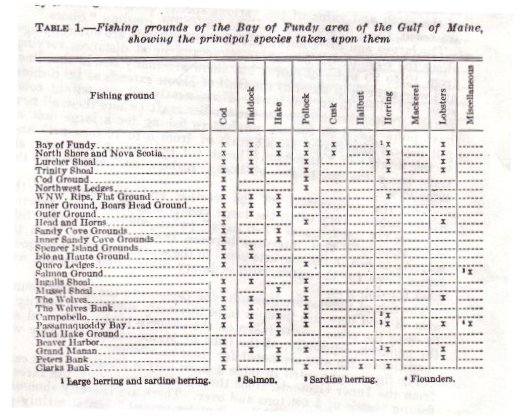
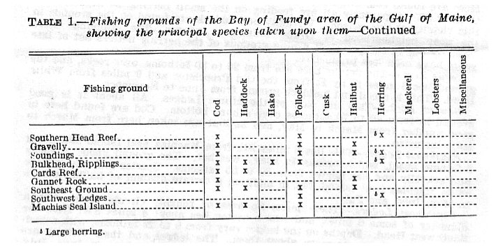
[Table I--Fishing Grounds of the Bay of Fundy Area of the Gulf of Maine, showing the principal species taken upon them.]