Fishing Grounds of the Gulf of Maine. 1929
INNER GROUNDS
Under this heading are listed those grounds of the innermost chain of shoals, ledges, and "fishing spots", patches of rocky and gravelly bottom, the deeper water between them being over the muddy ground, which line the coast of the Gulf of Maine, making of it an almost continuous piece of fishing ground. In the Reports of the United States Bureau of Fisheries, on which all the statistics of the catch and value of the various species quoted in this report are based, these figures are grouped under the heading "Shore".
The larger and more important of these grounds are outcroppings along the edge of the 50-fathom curve and lie at distances varying from 12 to 20 miles offshore; but there are many inside this line, and where the deep water of the Gulf of Maine extends so far inshore some are close in to the land. Thus, nearly all are within comparatively easy reach even for the smaller craft (where these all now have power) and so furnish productive fishing for a large fleet of gill netters and sloops (small craft of from 5 to 10 tons net) and to the myriad of "under-ton" boats (of less than 5 tons net), all these being enabled to run offshore, "make a set," and return the same day.
With the uncertainties of the weather and the hazards of the winter fishing, very often the large vessels also follow this practice on those not too frequent "fish days" (when conditions permit fishing "outside ") that intervene between the storms; and with the scarcity of fish in the markets usual to the season and the consequent better price for the catch, with ordinary fishing luck they are well paid for doing so.
The fish of these shore grounds, due perhaps to the greater abundance of food here, are thought to be distinctly superior in quality to those of the same species taken on the offshore banks. The cod and the haddock, especially, of the Gulf of Maine are particularly well conditioned fish and are noted for their excellence.
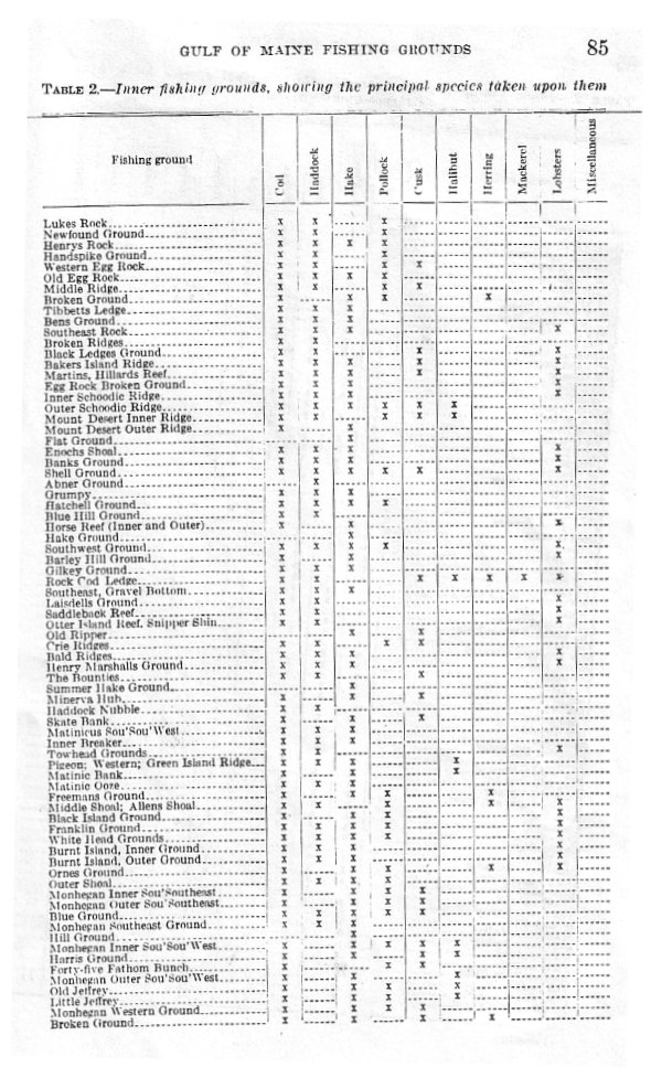
The figures presented in Table 2 show only a fraction of the catch from the Inner Grounds, since they deal entirely with the fares of fishing vessels of 5 net tons and over. There are literally thousands of the so-called "licensed" or "under-tonned" boats, mainly gill-netters, that take millions of pounds from these waters annually, principally cod and haddock.
On the Maine coast and across the line in New Brunswick there are more than 300 weirs which furnished to American smokers and canners during the year 1923 (whose figures have been chosen as representing an average season) 77,000,000 pounds of herring. On the coast of Massachusetts there are 50 or more weirs and fish traps, and from the Isle of Shoals to Pemaquid Point in Maine there are more than 50 floating traps in the various bays, on the points of offshore islands, or even in the open sea, and all these take a rich harvest from these waters.
Then, too, there is the lobster fishery, more important in the Gulf of Maine than anywhere else in the United States.
Of these various branches of the fisheries industries few statistics are available, yet we may say that the figures of the 1919 census showed that the "under-ton" boats mentioned landed 5,324,426 pounds of fish at the port of Boston, mostly of cod and haddock, and that the same type of craft in 1923 landed at Portland, Me., more than 3,000,000 pounds, principally of ground fish. We also know that every island, hamlet, village, town, and city along this nearly 4,000 'miles of coast line takes its toll from the sea.
Lukes Rock. This rock lies S. by E. 3 miles from Moosabec Light, circular in shape, and about 1 mile in diameter. Depths are from 25 to 35 fathoms; the bottom is rocks, gravel, and mud. This is mainly a small-boat fishing ground, but there is some vessel fishing. Hake are taken here from June to September, inclusive; cod are present about the rocks the year around. Pollock are here in spring and fall, and haddock from December to February, inclusive. Fishing is by trawl and hand line.
Newfound Ground. A small rocky spot about 1/4 mile across with an automatic buoy in the center for guidance into the Bay of Fundy. This is a small-boat ground having depths averaging 18 fathoms. It lies about 3 miles S. by W. from Moosabec Light. Species and seasons are as on Lukes Rock. Fishing is by trawl and hand line.
Henrys Rock. Five miles SW. by S. from Moosabec Light. 1/4 mile in diameter, and 30 fathoms over a level bottom. Fishing is done by hand line and trawl. Cod are present the year around, a few haddock in the fall, hake in the summer but not in the fall, and pollock in spring and fall.
Handspike Ground. Eight miles SW. by S. from Moosabec Light, nearly circular in form, and ỳ mile across. It has a bottom of rocks and depths of from 35 to 40 fathoms. Species and seasons are the same as on Lukes Rock, but mainly cod and pollock are taken here by trawl and hand line.
Western Egg Rock. This is SW. from Moosabec Light, 8 miles distant, lying in a NE. and SW. direction, 3 miles long by 1 mile wide. The bottom is irregular, sharp, and rocky and has 25 to 30 fathoms. Fishing here is mostly by hand line, the ground being said to be too rough for trawling. This is a small-boat ground, and fishing is done mainly in the summer season. Cod and pollock are taken in the spring, summer, and fall; haddock are present in spring and fall; and cusk in 35 to 40 fathoms in spring and fall. This is not a hake ground.
Old Egg Rock. This rock is WSW. from Moosabec Light, 6 miles distant, and running in a NE. and SW. direction. It is 3 miles long by 1 mile wide; has a rocky bottom and depths of 25 to 30 fathoms. This is also a small-boat ground, where fishing is done mainly by hand lines, but trawls also are employed. This ground is fished by the larger vessels in the fall months when the weather is too rough for fishing on the outside grounds. Cod, haddock, and a few pollock are taken in spring and fall; hake in fair number in the fall months.
Middle Ridge. This is W. by S. from Moosabec Light 3 miles. It lies in a NE. and SW. direction and is about 1 mile long by Ẅ mile wide. The depths are from 18 to 25 fathoms and the bottom is rough and rocky. It is a small-boat ground mostly and of little importance as a fishing ground. Cod are present the year around haddock in late spring and summer with a smaller number in the fall. Cusk are here the year around. A few pollock are here in the spring and fall. Broken Ground. This lies S by E from Moosabec light, 15 miles, whence the ground extends WSW to within 4 miles of Mount Desert Rock with an average width of 1 mile. The depths run from 15 to 100 fathoms. The shallows are sharp and rocky; the deeps, clay and gravel. There are places Ẅ mile long and others 3 miles long having depths of 70 fathoms.
Several of these spots have special names: Crawley's Rocks, Puzzling Rock, The Ridges. The grounds mentioned here and those previously mentioned are known to the fishermen as the Moosabec Ridges. All these seem to be fishing spots cropping out upon the 50 fathom curve. On the Broken Ground the fishing season is from June 1 through September. Herring usually are abundant here from May to September. Cod are taken outside of the grounds in spring and fall. Pollock and small cod are taken on the shoals in summer and fall, and hake on the mud bottom in summer and fall and hake on the mud bottom in summer and fall.
Tibbetts' Ledge. This lies east from Petit Manan 4 or 5 miles. The marks are Schoodic Island over Green Island of Petit Manan and the Ladle over Nash's Island. This ledge consists of two rocky shoals with depths of 3 to 3 Ẅ fathoms, about one acre apiece in extent and 1/4 mile apart lying NW and SE from each other. To the westward of these is broken ground nearly to Petit Manan. These are favorite small-boat grounds. The eastern ledge drops suddenly into the mud. In May large cod are caught over the muddy bottom just E of the ledge in 27 to 30 fathoms. Hake and haddock are taken in late spring (May) and fall. Fishing is by hand line and trawl.
Ben's Ground. Lies ESE from Petit Manan 4 or 5 miles. The marks are Petit Manan Light to northward of Middle Hill of Mount Desert and Humpback Mountain on the west side of Trafton's Island or Pond Island Light to the eastward of Jordan's Delight. The ground is circular in shape, about 3/4 mile across, having 14 to 30 fathoms of water. The bottom is of rocks and mud. This ground is of little importance except as a small-boat ground in summer for cod and haddock. Hake are taken on the muddy bottom near it, It is a winter haddock ground in calm weather, these fish leaving it in the storms, the water being somewhat too shallow for them to "ride out a blow" in comfort, Such at least is the reason the fishermen give for the sudden cessation of their taking on shoal grounds after a period of heavy weather,
Southeast Rock. .This is a ledge, nearly uncovered at low tide on its shoalest spot, SSE from Petit Manan and 4 Ẅ miles distant, The shoal portions slope toward the NE a distance of 4 miles over an irregular bottom, Depths vary from 17 to 30 fathoms, The shoals are rocky, and the deeps are muddy, Cod and haddock are taken here in May and June, hake from July to September, It is a good lobster ground, also, Fishing here is by handline and trawl operated from vessels and small boats from near-by Maine ports,
Southeast Rock. .This is a ledge, nearly uncovered at low tide on its shoalest spot, SSE from Petit Manan and 4 Ẅ miles distant, The shoal portions slope toward the NE a distance of 4 miles over an irregular bottom, Depths vary from 17 to 30 fathoms, The shoals are rocky, and the deeps are muddy, Cod and haddock are taken here in May and June, hake from July to September, It is a good lobster ground, also, Fishing here is by handline and trawl operated from vessels and small boats from near-by Maine ports,
Broken Ridges aka Joe Roy Ground, This lies SSE from Petit Manan 7 miles to the center. It is 2 miles long NE and SW and one mile wide and from 27 to 33 fathoms, and the bottom of rocks and mud is very uneven, The shoalest portion is near the center. It is said to be a good cod and haddock ground, and is mainly a small boat ground, although some vessel fishing is carried on here in the spring.
Black Ledges Ground. This ground lies between Jordan's Delight and the Halibut Ledges, or Black Ledges. It is a good haddock ground for a brief season in the spring and early summer when the fish are following the herring schools. In general it is a small-boat ground on which chiefly hand lines and trawls are operated, A few cod and cusk are taken here in the fall, and it is a good lobster ground.
Bakers Island Ridge. This is a narrow ledge making out from Bakers Island E, by N. The eastern part bears S. by E. from Schoodic Island 3/4 mile distant The ridge is much broken, its average width being Ẅ mile, and it has depths of from 20 to 25 fathoms over a rocky and gravelly bottom. It is not much fished on the shoaler spots, but in 30 to 35 fathoms, on a muddy bottom, hake are abundant from July to October, inclusive. Cod and cusk are found here in the spring and fall; haddock from October to January, inclusive. Fishing here is done by small boats and small vessels mainly from Bass Harbor and Southwest Harbor by trawl and hand line. It is a very good lobster ground.
Martins Ground; Hillards Reef. The center bears WSW. from Schoodlc Point, distant 3 miles. It is a rocky patch of 4 or 5 acres and has depths of from 15 to 25 fathoms. It is not important except for its hand-lining for cod and haddock in the spring and fall months and for hake in the fall. It is a good lobster ground.
Egg Rock Broken Ground. This is a rocky ridge making out S. by W. from Egg Rock Ledges and is about 2 miles long by 14 miles wide. It has an irregular bottom, with depths from 9 to 15 fathoms. This ridge, with Martins and Seaveys Grounds, divides the western or Bakers Island mud channel from Schoodic mud channel. Both these were formerly considered very good hake grounds but, while still good, are not as profitable for hake fishing as in past years. Haddock are taken on the ridge in the spring and in October, November, and December. A few cod are taken in the spring and fall. Fishing is by trawl and hand line. It is a good lobster ground.
Inner Schoodic Ridge. This ridge bears SE. by S. from Bakers Island, the center distant 12 miles. This ground is nearly circular in form, about 4 miles in diameter, and has depths running from 18 to 60 fathoms. The bottom is of rocks, gravel, and mud; the shoaler portions are sharp and rocky. Vessels from Maine ports use this ground, fishing by hand line and trawl. Cod and haddock are abundant here in spring and fall, and hake fishing is good through the summer. It is a good lobster ground.
Outer Schoodic Ridge. The northwest part of this ground bears SE. from Bakers Island, from which it is distant 22 miles. It lies 7 miles outside Inner Schoodic, has long been considered one of the best shore fishing grounds of the Maine coast, and still seems to deserve the reputation. The ridge is about 8 miles long in a NE. and SW. direction, lying nearly parallel with the adjacent coast. Its greatest breadth is 6 miles. The bottom is broken and irregular and has depths from 22 to 80 fathoms over rocks and gravel on the shoaler parts and mud on the deeps. Principally Maine vessels fish this ground, using hand line and trawl. Cod, pollock, haddock, cusk, and hake are present here from June to November, and a few large halibut, up to 300 pounds in weight, are taken here in June and July.
Mount Desert Outer Ridge. This ridge lies SE. by E. from the Big Hill of Mount Desert Island. From Schoodic Island to the center of this ground is about 25 miles. Its length E. by N. and W. by S, is 2 miles; its breadth 3/4 mile. Depths are from 45 to 60 fathoms; the shoals are rocky, but on the sides sand and clay predominate. This is a comparatively small ground, but it furnishes good cod fishing in the spring (April to July) and fall. Cusk are taken in the spring and fall. Virtually no haddock are taken here. Hake are found in the deep water on the W. and SW. in spring, summer, and fall; trawl lines principally are used here. It is a good lobster ground but is too distant for present fishing methods.
Flat Ground. .This ground lies between Mount Desert and Swan Island, SW. from Long Island. In 50 fathoms, on a hard mud bottom, there is good fishing for hake in the summer. Fishing is by hand line and trawl.
Enoch's Shoal, This shoal lies ENE. 3 miles from Great Duck Island. This is a small hummock on the outer parts of a ridge extending out to it from Great Duck island. It has a sharp, rocky bottom with depths of about 18 fathoms. Hand lining and trawling are the methods employed to take a few cod in early spring; haddock are here in small numbers in the summer as well as a small quantity of hake. It is a good lobster ground.
Banks Ground, The center bears SE. by S. from Great Duck Island, distant about 5 miles. It is about 1Ẅ miles long in a NE. and SW. direction by 1/4 mile wide and has a mud bottom with depths from 35 to 50 fathoms. It is mainly a small-boat ground, fished mostly in the summer, when hake are fairly abundant and there are a few haddock and cod. It is a lobster ground, also.
Shell Ground, This lies SE. from Long island Head, from which the center of the ground is distant 6 miles. It is 2 miles long, in a NE. and SW. direction and about Ẅ mile wide. In the middle portion is a shoal of 25 fathoms, its bottom sharp rocks. On all sides of this shoal the bottom is quite irregular, consisting of pebbles and mud. The greatest depth, near the edge of the bank, is 50 fathoms. Cod and haddock, together with a few cusk and pollock, are taken here in June, July, and August and even into the late fall, but it is mainly a hake fishing ground for small boats and an occasional larger craft, all using hand line and trawl. It is a good lobster ground.
Abner Ground. This ground is SSE. from Gott's Island, distant 8 miles. It extends 1Ẅ miles in a NE. and SW. direction and is about 1/4 mile wide. The bottom is broken, rocks and mud, with depths of from 25 to 50 fathoms. This is principally a haddock ground, the best season being in July and August, and is resorted to mostly by small craft.
Grumpy. Extends from SE. 4Ẅ miles from Eastern Ear of Isle au Haute to SE. 1/4 E. from the western head of Isle au Haute, distant 7 miles. This ground is 2Ẅ miles long by 3/4 mile wide and has a small shoal of 14 fathoms on the northeast part. Over the rest of the ground the average depths run from 35 to 40 fathoms over a gravelly bottom.
Though not of great importance of late years, this was formerly considered one of the best inshore grounds for cod for the entire year and for haddock in winter. Hake usually are abundant just off the southeast edge in summer. This bank is mostly fished by craft from ports of eastern Maine--small boats as a rule--and the principal method is by trawling, although there is considerable hand-lining for cod in 25 fathoms in June and July. Marks: Big Camden Mountain over the Eastern Ear of Isle au Haute; Fog Island in Jericho Bay, touching on the eastern part of Big Spoon Island; Brimstone between Isle au Haute and the Western Ear.
Hatchell Ground. This ground lies SE. by E 3/4 E. 9Ẅ miles from the western head of Isle au Haute. Marks are eastern Mount Desert Hill in the Middle Saddle of Long island, and Little Spoon Island in the great or center Saddle of Isle au Haute.
Blue Hill Ground. This ground lies approximately E: by S. ẅ S from the western head of Isle au Haute, distant 7 miles. The bottom consists of gravel and pebbles. Marks: Brimstone Island out by the western head of Isle au Haute and Blue Hill on the west side of Marshall Island. These marks lead to a depth of 25 fathoms on the northeast part of the ground, deepening southwest to 40 fathoms in 1 mile from the shoaler part, which is about Ẅ mile wide, part of the ground, deepening southwest to 40 fathoms in 1 mile from the shoaler part, which is about Ẅ mile wide. This is a good ground for cod in the spring and fall but is best for haddock during the entire winter. Hand lines and trawl are used.
Inner Horse Reef. This reef lies SE. ẅ E 1Ẅ miles from the eastern ear of isle au Haute. There is a shoal here of 25 fathoms about 1/8 mile in diameter. From this the water gradually deepens to NE. for Ẅ mile, where it drops off into the mud. Depths on this northeast portion are about 35 fathoms. The bottom is of pebbles and gravel. In spring and fall this is a good cod ground. Hake are found close to the edge in summer. Fishing is by small craft, generally, using trawl and handline. It is a good lobster ground. Marks: Bring Blue Hill Mountain in the saddle of White Horse; Brimstone showing between Western Ear and Isle au Haute.
Outer Horse Reef. .This is a short distance SW. from the Inner Reef, with only a narrow gully between. The small shoal falls off rapidly on all sides. It has a depths of 30 fathoms. Over a space 1/4 mile in diameter the bottom is gravelly. Seasons and species are as on Inner Horse Reef.
Hake Ground, North of Monhegan island lies a patch called the Hake Ground or Mud Channel, the first name because of the abundance of hake taken here during June, July, and August. It extends from just outside White Head to abreast of Monhegan Island on the northern side. The depths vary from 20 to 45 fathoms, and the ground is still considered one of the best hake grounds alongshore. It is fished by small boats and vessels when the dogfish are on the outer grounds. This is a good haddock ground in December and January, as well as a good lobster ground.
Southwest Ground. .This lies 2 miles SW. from the western head of Isle au Haute. It is circular in form, Ẅ mile in diameter and has a gravelly bottom with depths varying from 35 to 40 fathoms. It is a cod ground from April to June and from September to November, inclusive. A few pollock and haddock are taken with the cod. Hake are abundant in summer close to Isle au Haute. Handlines and trawls are used in the fishing. It is also a good lobster ground.
Barley Hill Ground. .vThis ground lies NNE. from Seal Island and SSW from the western head of Isle au Haute directly in line between the two, about 3 Ẅ miles distant from each point. It is circular in form, has 28 to 30 fathoms of water, and the bottom is mixed mud and rocks. This is a ground much resorted to by sloops and larger vessels, and the fishing is by hand line and trawls. It is a good cod ground in spring and fall and a hake ground on the mud and rocks in summer. Occasionally a few halibut are taken here during June and July. It is also a lobster ground.
Gilkey Ground. .This bears S. from the western head of Isle au Haute. 4 miles distant. It extends ENE. and WSW about 1Ẅ miles long by 1/3 mile wide. The bottom is rocky on the shoals where depths are about 23 fathoms sloping to 35 fathoms on the southwest part., where the bottom is gravelly and comparatively smooth.
Rock Cod Ledge. This ledge lies NE. of Seal Island 1 mile. It has a depth of 3 Ẅ fathoms on the shoalest part, deepening gradually on all sides for a considerable distance. The bottom is of sharp rocks and is broken in places. Rock cod area present in fair numbers in spring and fall, and this is a mackerel and herring ground in their seasons. Haddock are abundant in the fall close in to the rocks of Seal Island in 6 to 15 fathoms. This is not a hake ground, although there are a few cusk to be had here on the deeper parts and an occasional small halibut is taken in the kelp on the shoal in June and July. It is a good lobster ground.
Gravel Bottom and Southeast Ground, These lie S. of Seal Island. forming an extensive piece of fairly level ground extensive piece of fairly level ground. The western that bears a little E. of S. and the eastern part about ESE. from the island. It is about 5 or 10 miles in diameter. While this is really but one piece of ground, the eastern part is called the Southeast Ground and the western part, from the nature of its bottom.
The Gravel Bottom. .The eastern portion is muddy and has 40 to 60 fathoms. The western has 35 to 40 fathoms. It is a good cod ground in winter and spring. Haddock are present from November to March, inclusive; hake in summer. Fishing is done mainly by trawling by sloops and vessels.
Laisdells Ground, This is a small, rocky spot outside the Brandy Ledges. It is about 1/4 acre in extent and has a sharp rocky bottom with 20 fathoms of water over it. It is the best cod and haddock ground in Isle au Haute Bay. This is chiefly a small boat ground and is also a lobster ground.
Saddleback Reef. .This reef lies S. from Saddle-back Ledge, 3/4 mile distant. It is about 2/3 mile long N and S by 1/4 mile wide. Depths are from 15 to 35 fathoms over a broken and rocky bottom. Cod are taken here by hand line in May and June; haddock and cod by trawling in fall and winter (November to January 1). It is a good lobster ground and chiefly a small-boat ground.
Otter Island Reef; Snipper Shin; Western Reef, These are names applied to different sections of an irregular, broken piece of rocky ground about halfway between Vinalhaven and Seal Island. Otter Island Reef is the eastern section, lying 4 miles W. by S. by 1/4 S. from the western head of Isle au Haute. Depths here are from 10 to 25 fathoms over a rocky bottom. The trawl, formerly not much used here, is now in general use. This is a cod and haddock ground at seasons when these fish are in shoal water, but it is best for cod in winter and spring and for haddock in the fall, from November 1 to January 1.
Old Ripper. This lies S. from the Western Ground (Western Reef) and 10 miles WSW. from Criehaven or Ragged Island. Apparently this is a part of the Western Ground. On the deep-water mud bottom between these (Ripper and Western Reef) is good hake fishing in summer, and cusk are abundant from May to the time when the dogfish strike the ground, usually about July 5 to 10.
Crie Ridges. These lie 4 miles NW. from Matinicus Rock, 4 miles WSW. from Criehaven or Ragged Island, and run SE. from Western Ground toward Matinicus, distant 4Ẅ to 5 miles. Cod, pollock, and cusk are here in the spring, and haddock are abundant in the fall.
Bald Ridges, These begin just outside Wooden Ball Island and run off in a nearly direct line for Matinicus Rock. They are each from 1/4 to Ẅ mile wide, are quite close together, the distances between them being not over Ẅ mile, and they are almost parallel with each other. Soundings show from 15 to 30 fathoms upon them, with a broken, rocky bottom. The shoalest water is about 1 mile from Wooden Ball Island, the depth increasing toward the southern end.
Henry Marshalls Ground, This ground lies S. by W. from Matinicus Rock about 3 miles; its area is about 2 acres. The shoaler portion has a depth of 35 fathoms and a gravelly bottom; on the edge the depth is 45 fathoms and the bottom is of rocks and mud. Cod are taken here in the spring, haddock in January and February, and hake in the summer months. It is a good lobster ground.
The Bounties (The Bowdies), This ground bears SE. by S Ẅ S distant 6 miles from Wooden Ball Island. It is nearly circular in form, about 4 miles across, and has depths from 40 to 60 fathoms. The bottom, of gravel and rocks, is somewhat broken. It is a good cod and cusk ground in spring and fall and a haddock ground in winter and is fished by vessels and sloops, mainly by trawling but with a certain amount of hand lining, in May and June. A summer hake ground extends from 3 miles ESE. of Seal Island to 4 miles SSE of the Wooden Ball, thus it is about 7 Ẅ miles long by some 2 Ẅ miles wide. The depths here are from 35 to 60 fathoms.
Summer Hake Ground, A summer hake ground extends from 8 miles SE. of the eastern Ear of Isle au Haute to 3 miles SE. of Long Island in 35 to 60 fathoms on a bottom of hard mud. This piece of ground is about 15 miles long by 4 miles wide.
Minerva Hub. This bears SSE. from Matinicus Rock, distant 6 miles. This is a small, gravelly spot about 1/4 mile in diameter and with a depth of 35 fathoms, abounding with cod in spring and fall. It is a summer ground for hake and cusk. Hand lines and trawls are used.
Haddock Nubble. This lies SE. Ẅ S. from Matinicus Rock, distant 16 miles, and has an average depth of 50 fathoms over a small, circular patch some 2,000 feet across. The bottom is of gravel and rocks, and "lemons" and marine growths of like nature are abundant. This is a June cod ground, usually furnishing good haddocking, also, from November to January, inclusive.
Skate Bank. This bank bears SSE. from Matinicus Rock, distant 12 miles. It is about 2 miles in diameter and nearly circular in form. Depths are from 35 to 60 fathoms. The bottom is gravelly but quite uneven. The best season on this ground for cod and cusk is from April to July. Hake abound in July and August. Hand lines and trawls are used here, fished by sloops and vessels.
Matinicus Sou'Sou'West Grounds These grounds bear SSW. from Matinicus Rock, from which the inner edge of the grounds is distant 6 miles. They extend about 9 miles N. and S. and have about the same width, being nearly triangular in shape, broadest at the northern end. On the northern part there is a shoal of about 30 fathoms 2 miles long E. and W. and 1 mile wide. Sharp rocks cover this, but the ground is not broken and drops off gradually to depths of 50 to 55 fathoms or even to 60 fathoms on the southern part. Outside of the shoal the bottom is pebbly and gravelly. This is one of the best cod and haddock grounds in the vicinity. Cod are sometimes abundant here all winter; haddock are found here from December 1 to February and are more abundant than the cod. Hake are plentiful on this ground and in 60 fathoms on the mud off the edge SE. of this ground during the summer season. Marks: The high pinnacle on the eastern end of Wooden Ball, showing just out by Matinicus Rock, SW. by S. from the rock, 5 miles.
Inner Breaker. This lies 2 miles W. of the southwest point of Matinicus Island. It is a rocky shoal about 1 acre in extent and having 7 fathoms of water. From this shoal the bottom slopes gradually to depths of 25 to 30 fathoms, and this slope furnishes good fishing for cod in May and June, while haddock are here in December and January. A good school of hake is found on the edge of the ground in summer. The bottom is rocky and broken and, while sharp, is fished with trawls as well as hand lines. It is mostly a small-boat ground.
Towhead Grounds. These grounds hear N. by E. Ẅ E. from Matinicus Island, from which they are distant 2Ẅ miles. Depths are from 12 to 30 fathoms. It is somewhat irregular in shape and has a very rocky, broken bottom. The ground is from 2 Ẅ to 3 miles long and Ẅ to 1 Ẅ miles wide. It extends E. by S. and W. by N. and is considered one of the best inside shoal grounds for cod and haddock in the bay. Hand lines and trawls are used here now, although in former times this and the preceding grounds were considered too sharp for the use of trawls. Both these are good lobster grounds and chiefly small-boat grounds.
Green Island Ridge (or Western Ridge) and the Pigeon Ground. The northern portion of this ridge lies 6Ẅ miles NW. by W. from Matinicus Rock, from which the ground extends about 7 miles in a SSW. direction. The greatest width is not over 1 mile. Depths are from 15 to 30 fathoms. The bottom is broken and rocky. It is a good cod ground in the spring and fall. Haddock are found here in June, November, and December. In summer this is a good hake ground. Halibut are found on the shoals (10 fathoms) and about the northern part of Western Green Island, on the sandy bottom during June and July.
Matinic Bank. This is an extension of the shore soundings that make out to the southward and eastward of Matinic a distance of 2 or 3 miles, with depths (outside of 1Ẅ miles) of 23 to 30 fathoms. The bottom is level, consisting of rocks, pebbles, and gravel, and the ground abounds in cod in the season from March to June. Just off the edge, in depths of from 40 to 50 fathoms, the bottom is soft mud, on which hake abound in summer. Very few haddock are taken on this bank. Halibut are sometimes abundant here in 10 to 15 fathoms during May and June.
Matinic Ooze. This is a flat bottom, composed of ooze and shells, that makes off to the eastward of the Haddock Ledge and Shoal and bears about S. from Matinic. The Haddock Shoal and the Ooze are really parts of one ground, though they have been given different names by the fishermen. The Haddock Shoal (3 miles S. by B. from the Seal Ledge: breaks in rough weather) is thought to be poor ground and is but little fished, although it is a fall haddock ground. The Ooze falls off gradually, reaching a depth of 50 fathoms on the outer part. It is considered fair fishing ground for cod and haddock in the spring and for cod and hake in the summer and fall.
Freemans Ground. This ground lies 6 Ẅ miles E. from Monhegan Island between Ornes Ground and Matlnicus Western Ground. It is 3 miles long and 1 mile wide and runs in a NE. and SW. direction. There is a shoal on the southwest part having 20 fathoms over a sharp rocky bottom. The rest of the ground has depths of 25 to 40 fathoms, the bottom of rocks, gravel, and shells, in some places uneven and in others smooth. This is a good spring ground for cod and for cod, hake, and pollock in the fall. Haddock are not numerous on this ground, though a few are usually to be found here in December. Herring are here May to August.
Middle Shoal, Pollock Rip, Allens Shoal, and Deckers Shoal. These are small rocky patches lying to eastward of Monhegan Island and northerly from the Outer Shoal. They have depths from 6 to 30 fathoms over a sharp, rocky, and broken bottom. Middle Shoal is 2 miles from the island. Pollock Rip 1 Ẅ miles. Allens Shoal 1 1/4 miles, having 5Ẅ fathoms and breaking in rough weather; and Deckers Shoal 1 mile. Depths vary here from 6 to 30 fathoms over a bottom generally sharp and rocky. The principal fishing here is hand-lining for cod in the spring during the herring season and in the fall in "squid time". A few pollock are taken here also.
A number of small patches lie westerly from the Outer Shoal and close to Monhegan Island. These are the Cusk Ground with a depth of 20 to 35 fathoms; Gull Rock Ledge (breaks in rough weather) 3 Ẅ fathoms; Lobster Point Ground, 15 to 30 fathoms; Inner Spring Ground, 15 to 30 fathoms; Outer Spring Ground 25 to 30 fathoms. All these are fished for cod nearly all the year, for haddock in December and January, and for pollock in early spring and late fall. The Spring Grounds are near the harbor and so are fished before the others. All are lobster grounds. Small boats and vessels operate here.
Black Island Ground. This ground is ENE. 2 miles from Monhegan. 1 mile in diameter, has a shoal of 10 fathoms, and sharp rocky bottom in the center. The ground slopes gradually from this to the edges, where are 40 fathoms. Beyond the depths of 28 to 30 fathoms the bottom is gravelly and smoother. This is a cod ground in spring, and cod and hake are taken here on the edges in summer and fall. Pollock are found about the shoal in summer. It is a good lobster ground.
Franklin Ground. This ground is NE. by N. midway between Monhegan and Burnt Island, distant 4 miles. Cod and haddock are found here from April to June and pollock in summer. In summer and fall hake are taken by night fishing with hand line about the rocks in 20 to 30 fathoms on the broken ground. Fishing here is by hand-lining in summer and trawling in fall and winter. It is a lobster ground.
White Head Ground. Depths on the shoal (the White Hub: Bring Budd cottage out by White Head, Black Head. and Allens Island touching) are 7 fathoms, thence to 20 fathoms on the edges about it. This ground extends NE. and SW., 2 miles long by 1/4 mile wide. The bottom is chiefly broken, of rocks, and with spots of coarse gravel and sand. Fish and their seasons are as on Franklin Ground. Marks: Bring Black Head, White Head, and Gull Head in range on the east side of Monhegan Island.
Burnt Island, Inner Ridge aka Andrews Shoal. This is NE. by E. from Monhegan, distant 5 miles. It is a broken ground with depths from 15 to 20 fathoms, the bottom rocky and gravelly, with occasional mud holes. It extends NE. about 4 miles, nearly to Roaring Bull Ledge, and is Ẅ mile wide. There are strong tidal currents here, the flood being NE., the ebb SW. It is a cod ground from April to June, and cod and hake are taken from September to November; haddock in December. It is a good lobster ground.
Burnt Island, Outer Ridge. This ground is parallel with the Inner Ridge and at a distance of 3/4 mile. Depths are from 5 to 25 fathoms, the bottom being rather less broken than on the Inner Ridge. Fishing seasons and species are as on Inner Ridge. Hand-lining is done mostly because of strong tides. It is a good lobster ground.
Ornes Ground. This ground bears E., distant 4 Ẅ miles from Monhegan Light to the center. It is 1 mile long. E. and W. and 1 mile wide. Depths are from 30 to 45 fathoms. On the shoal parts the bottom is of sharp rocks and broken. On other parts it is generally pebbly and quite level.
The shoal lies toward the eastern part of the ground and is a good spring cod ground; also a pollock ground in the spring and fall. It is a night fishing ground for hake, by hand lining close to the rocks during September and October. Herring are abundant here usually in May and June. It is a good lobster ground. Fishing is done by hand lines and trawls.
Outer Shoal. This ground is ESE from Monhegan Light about 2 Ẅ miles. It is circular in form and about 1 Ẅ miles across. Depths are from 10 to 38 fathoms. There is a small rocky shoal in the center of the ground; the remainder of this piece has a gravelly bottom. This is a cod ground from spring to fall and a good pollock ground in September. A few haddock are taken here about the edges in December. Hake are abundant on the edges on the mud in 45 to 50 fathoms during the spring, summer and fall.
Monhegan Inner Sou'Southeast Ground. This ground is SSE from Monhegan Light. It is circular in form and 1 1/4 miles across. The center is 5 miles fro the light. Depths are from 30 to 50 fathoms, the shoalest water being on the eastern part, the shoal has a broken and rocky bottom, but the rest of the ground is gravelly and muddy. The principal fishes taken are cod and cusk in the spring, summer and fall. Very few haddock are found here. Pollock are numerous in the fall, when they are taken by hand lining. Hake are abundant in September and October. June is the best fishing month, except when the squid strike the ground in the fall. This is mainly a small boat ground, fished by trawls, hand lines and an increasing number of gill nets.
Monhegan Outer Sou'Southeast. Three miles outside the Inner Ground on the same bearing and similar in size and form. The bottom is rocky and muddy or of hard clay. The depths are from 35 to 55 fathoms. The same species are found here as on Inner Sou'Southeast and at the same seasons, and in addition, hand lining is done for cod in August and September.
Blue Ground. This is SE 1 Ẅ E from Monhegan, distant 14 miles; E 1 Ẅ S from Portland Lightship 45 miles, and SW from Matinicus Rock 9 miles to southern Edge. Fishermen usually take the Monhegan bearing for their starting point. This ground has a small shoal in the center, having 28 to 30 fathoms, from which the bottom slopes off to 45 and 60 fathoms on the edges. The shoal is broken and rocky, bu the deep water is over a level gravelly bottom. This ground is circular in form and about 2 miles across. It is both a small-boat and vessel ground, larger craft operating here mainly in the fall. Hake are found here in large numbers in summer and fall; cusk are taken in the deep water the year around but are most abundant in January. Cod are here the year around, the largest school occurring in February and March.
Monhegan Southeast Ground. This ground lies SE from Monhegan Island, the center distant 12 miles. This is nearly circular, 3 miles in diameter. The bottom is so broken that depths may vary much within a short distance, but depths are from 35 to 75 fathoms over a bottom of rocks, gravel and mud. Fishing is by trawl and handline. It is good cod ground from April to July; haddock are taken in December and hake in summer on the edges in 50 to 60 fathoms.
Hill Ground. This ground is SSW 9 miles from Matinic: between 3 and 4 miles long NE and SW and some 2 miles wide. The shoalest part has 35 fathoms and a rocky bottom. From this it slopes gradually to a depth of 50 fathoms over a bottom of mixed gravel, rocks and mud. Its best fishing is for hake, using both hand lines and trawls.
Monhegan Inner Sou'Sou'west Ground. this ground takes its name from its bearing, lying SSW from Monhegan light, distant 5 miles. Its width is 1 Ẅ miles, its length NNE and SSW is 1 1/4 miles. It has a sharp, broken, rocky bottom, including a small shoal of 20 fathoms and some hummocks of rather greater depths. The deepest water is in the neighborhood of 50 fathoms. Fishing here is from May until July for codfish and pollock: hake and cusk are in the deep water in the spring months and halibut on the shoal in July and September. This ground is principally fished by trawls, but there is considerable hand lining in September and October. Gillnetting, too, has become more common of later years.
Harris Ground. From 15 miles S Ẅ W from Monhegan island to 6 miles SSW. It has 40 to 50 fathoms over a bottom of sharp rocks and mud--a "blistery" bottom. Cod, cusk and hake are found here the year around. Halibut are here in June, July and August. Fishing is by trawling and hand lining, with very little gillnetting.
The 45 Fathom Bunch. Sixteen miles S 1Ẅ E from Monhegan. This is a great ground for June hand lining for cod. Thence 1 mile ENE to 70 fathom depth, which leads to a piece of ground leading to the Inner Fall, on which, on a hard bottom and mud where there is an abundance of "lemons" and similar forms, are found cod cusk and pollock in June. The ground is about 6 miles long, WSW and ENE by 1 mile wide.
Another Forty Five Fathom Bunch lies 22 miles S Ẅ E from Monhegan. This ground is 4 miles long by 1 mile wide, running ENE and WSW, and has depths from 45 to 75 fathoms. This is likewise a great cod hand lining ground in June.
Another of the same name lies 26 miles S 1Ẅ E from Monhegan. It has a 49 fathom shoal and the species and seasons are much the same as on the other grounds of the name. This is probably the ground known to other vessel captains as Toothaker Ridge. Monhegan Outer Sou'Sou'West. This ground is SSW from Monhegan Light. the center distant 9 miles It is 4 miles long, NNE and SSW and about 2 miles wide, and has 45 fathoms on the shoalest part but the depths generally are from 60 to 80 fathoms. The bottom generally is gravelly and quite level.
The ground is fished by both boats and vessels using hand lines and trawls. This is a cod ground in spring and fall. In summer hake are abundant here, and halibut are quite plentiful in July on the shoalest part.
Old Jeffrey. An exceedingly good ground. It is said that better fishing may be had here than on any other ground of its size in the vicinity. This piece of bottom bears SE from Pumpkin Rock, from which the center is distant about 6 miles. It is about 3 miles long NE and SW, and about 1 mile wide. The bottom is broken, of gravel and mud, with depths from 25 to 50 fathoms. Fishing here is by trawling and land-lining. In spring cod are most abundant, in late summer and fall hake, cod, and pollock are taken. Halibut are found on the shoaler parts in July.
Little Jeffrey. A small piece of broken, rocky bottom, roughly circular in form. Depths average 35 fathoms. Species and seasons are as on Old Jeffrey, from which it lies about 4 miles NE by E.
Monhegan Western Ground. This is a somewhat extensive ground lying about 4 Ẅ miles WSW from Monhegan Island. The depths range from 22 to 45 fathoms. Its length is 4 or 5 miles, and its greatest breadth is 2 miles on the eastern portion, gradually narrowing westward to about 1 mile.
The ground runs SE and NW. Pollock are found here in September and October. It is fished by hand lines, trawls and gill nets. Marks: Bring houses on New Harbor over the white cliff on Pemaquid 6 miles from New Harbor.
Broken Ground. The center bears nearly S. from Pumpkin Island (at entrance to Boothbay Harbor), distant 7 miles. It extends 4 miles in an ENE. and WSW direction and has an average width of 1ẅ miles. Depths are from 35 to 50 fathoms on a bottom of rocks and mud. Cod are taken here the year around; hake from June to September. Cusk also are found here all the year in 40 fathoms depths. It is fair herring ground on spring nights.
Great Ledge. Ten miles S. from Cape Newagen. It is about 4 miles long, SSW. and NNE and from 1 to 2 miles wide. There is said to be a shoal of 14 fathoms on the northern edge and another of 22 fathoms near the center. These are both broken and rocky, but the main part of the ground, having depths of 30 to 45 fathoms, is mostly composed of sand. is quite level, and slopes gradually toward the edge. It is a good ground for cod and haddock in winter and for cod in the spring. A few pollock are taken here, also. Halibut are found on the shoals in July. On these, also, are good lobster grounds. It is chiefly a small-boat and vessel ground, fishing being done by hand lines and trawls, with some gill netting. Marks: Show the sawtooth of Morse's Mountain coming out by Seguin on the western side; hold this until Pumpkin Island comes onto White Island.
Barnum Head Grounds. These lie SSE. from Damariscove Island and are about 1 mile long by 400 yards wide. Depths are from 40 to 70 fathoms over broken ground of sharp rocks on the shoals, with mud on the deeper parts. This ground is fished by hand lines, gill nets, and trawls mainly by boats and small craft. Cod, haddock, and pollock are found here in the spring and fall months: hake in the muddy parts in summer. It is a summer hand-line ground for cod and pollock also.
Marks: Bring the peak of Heron Island on Damariscove and the "Whistler" on Seguin, 7 miles from Damariscove Island (this gives 21-fathom soundings) or Big White Island's inner part just touching on Barnum Head; Morse Mountain (in Kennebec) touching on eastern part of Seguin to make a sawtooth.
Peterson's Ground. Lies distant SW. from Monhegan 20 miles and SSE. from Seguin 16 miles. This is about 3 miles long in an ENE. and WSW. direction by about 1Ẅ miles wide. The northern and western edges rise sharply from the 85 or 90 fathoms of the muddy bottom about it to 60 fathoms over a bottom of rocks and stones. Easterly and southerly the ground slopes away gradually over hard gravel to 90 fathoms. Cod and hake furnish the best fishing here--at its peak during October and November.
Cusk Ridge. It lies S. Ẅ E. 12 miles from Pumpkin Island, 3Ẅ to 4 miles long, NE. and SW., and 1/4 mile wide. This ground is somewhat difficult to find. It has a bottom of black gravel and rocks with 30 to 60 fathoms of water over it. A "blistery" bottom that is a cod ground the year around, the best of the fishing occurring in the spring months. Hake are abundant in the fall, and cusk fishing is exceptionally good in the deep water in June.
Potato Patch. Three miles WNW. from Monhegan. A round nubble about 1/4 mile in diameter, of sharp, rocky bottom having about 40 fathoms over it. Cusk and cod are taken on the shoal and hake from the muddy edges about it.
The Apron. Four and one-half miles from Monhegan. Marks are the tripod on Eastern Egg Rock over Franklin Island Light; Monhegan Light over the middle of Manana. Its length is 5 miles and its width 3 miles. It is a broken piece of ground with 10 to 45 fathoms. Cod are present the year around and haddock all the year except for a few weeks in summer. Cusk are here most of the year, but the season for pollock is September.
Henry Gallant Ridges. The inner one lies 16 Ẅ miles S. by E. of Monhegan Island, extending in a NNE. and SSW. direction, about 1 mile long by 1/4 mile wide. The outer ridge lies about 1ỳ miles farther from the island on the same bearing as the first and paralleling it and apparently is about the same size. The bottom on both shoals is of gravel and black rocks with depths averaging 45 fathoms but rising from the 80 and 90 fathoms of the surrounding muddy ground. Both these are year-around cod grounds, the spring months, however, having The largest school. Cusk also are abundant on both shoals in the spring.
Mosers Ledge, also known as Middle Ground. This piece of shoal ground lies about midway between Monhegan Island and Pemaquid and has a 3-fathom shoal on the eastern part where the sea breaks in heavy weather. This shoal, called Mosers Ledge, is broken and rocky but slopes gradually to the SW., reaching 48 fathoms, with a bottom of gravel and mud on the deepest part. The ground is about 2 miles long NE. and SW. and about 1 mile wide. It is good ground for cod and haddock in the spring and for herring in June and other top-schooling fish In their season. Mackerel occur in late August and September. It is a lobster ground the year around.
Johns Head Ground. About 4 miles SSE. from Pemaquid Point. Depths are from 25 to 15 fathoms over a sandy bottom, making a good cod ground in April and May. The ground is of circular form about 1 mile in diameter. Hand lines and trawls, together with some gill nets, are used on the sand shoal.
White Island Ground. This is ESE from White Island, from which its inner edge is distant ỳ mile and the outer edge about 4 miles. Of triangular outline, it is widest at the outer end. It is very broken and uneven and has depths from 6 to 30 fathoms. In some places the bottom is gravelly, but on the shoal it is sharp, broken rocks. The small, rocky spots are known by other names, such as Browns Head Ground (a herring ground in June), where the fishermen catch a few rock cod. The sandy bottom furnishes good fares of haddock in May and June. "Bobber trawling" is the usual method used here in June. This ground is fished mainly by small boats and sloops using hand lines and trawls.
Steamboat Ground. Seven miles WSW. from Monhegan Island; it is 3 miles long, NE. and SW, and Ẅ mile wide. Its bottom is broken with patches of rocks. Depths are from 25 to 50 fathoms, the shoalest 20 fathoms. This is fished by hand lines and trawls mainly by craft from New Harbor. Cod are found here the year around but are most abundant in the fall. Haddock are present all the spring and fall; hake through the summer months; pollock in the fall. Cusk are most abundant in the spring. A certain amount of lobster fishing is done here.
Inner and Outer Boutens (Bootlegs). The inner ground lies 3 miles SW. from Monhegan Island. It is about 1 mile long. NE. and SW., by 1/4 mile wide. It has a sharp, rocky bottom, shoalest in the center, where are 25 fathoms, sloping gradually southwest and falling off suddenly on the northeast side to the mud in 60 fathoms on the edges. Cod, haddock, and cusk are here the year around. Hake occur in summer on the muddy edges. It is a fairly good lobster ground on the shoal.
The Outer Bouten lies Ẅ mile SW. of the Inner, separated from it by a deep, muddy channel. It has a small shoal of 30 fathoms rising suddenly from the surrounding mud. Fish and seasons of their presence are as on Inner Bouten. Fishing on these grounds is mainly by hand line and trawl. Marks: The Tripod on Western Duck Island on the eastern side of the big eastern mountain of Camden: Black Head just out by White Head; White Head through the "Hole in the Wall." Hill Ground. This ground is SSW 9 miles from Matinic: between 3 and 4 miles long NE and SW and some 2 miles wide. The shoalest part has 35 fathoms and a rocky bottom. From this it slopes gradually to a depth of 50 fathoms over a bottom of mixed gravel, rocks and mud. Its best fishing is for hake, using both hand lines and trawls.
Seguin Sou'Sou'West Ground. This ground lies SSW. from the western part of Seguin Island, the center distant 4 miles. It is a rocky shoal, Ẅ mile long by 200 yards wide, with a Ẅ-acre shoal in the center. Depths are 7 to 14 fathoms. This is evidently a SSW continuation of the Hill Ground. It is fished by small boats for rock cod by hand-lining. Trawling is done in March for cod, and this is also a cod ground in April. It is both a small-boat and a vessel ground and is a lobster ground the year around. Marks: Elwells Rock touching the western side of Seguin, and Fullers Rock touching the southern part of Bald Head.
Seguin Ridge. This ridge is SSW. from Seguin Island, distant 5 miles. Four miles long. ESE. and WSW by Ẅ mile wide. There are a number of small rocky spots--hummocks of 9 to 14 fathoms in depth. In general the ground has from 10 to 40 fathoms over it, except as mentioned. Cod and cusk are taken in the spring, haddock in May and June. and hake in summer. It is a good cod ground in the fall and also a lobster ground. A few pollock are seined here in the spring. Fishing is by hand lines, gill netting, and trawling. Marks: Pond Island Light on the eastern spur of Seguin; Wooded Mark Island on Bald Head (Small Point).
Seguin Ground. This ground is SW. by S. from Seguin Island, distant about 7 miles to the center. About 4 miles long. NE. and SW., and a little more than 2 miles wide in the widest part. There is a small hummock called Bumpers Island Ground on the northern end with depths of 13 fathoms. The northern part is mostly rocky, but toward the south the bottom is gravelly and sloping, so that on the middle and southern portions there are depths of 35 to 45 fathoms. Cod, hake, and pollock are the principal fishes taken here and furnish some of the best fishing in this vicinity. Haddock are not common here but are abundant on the sandy bottom to the westward in April and May. Trawl fishing and gill netting are done in the spring for cod and hand lining for cod and pollock in October. It is a small-boat and vessel ground and a winter lobster ground.
McIntire Reef. This reef is SSW. from Bald Head (Cape Small Point). The distance to the center is 4Ẅ miles. This is 2 miles long. NE. and SW., by Ẅ mile wide. Marks are Yarmouth Island Hill over Mark Island and Pond Island Light on the northern part of Fullers Rock. This reef is very broken and hummocky and has a rocky bottom and depths from 14 to 20 fathoms. A shoal of 7 fathoms is on the northwest part, where there is good hand-lining for cod. It is a good lobster ground. Just east of this ground is a piece of bottom composed of hard mud and shells where hake usually are abundant in summer.
Seguin Hub. This lies SSE. 5 Ẅ miles from Seguin Light. There is a collection of half a dozen small hummocks rising from the 65 or 70 fathoms of the surrounding muddy bottom to 30 or 35 fathoms of rocky bottom. These are hand-line spots. Species and seasons are as on Seguin Ground, except that a great proportion of hake are taken here on mud from 60 fathoms down. It is a cod ground in spring and summer. Marks: Hunnewell Point Woods on Seguin; Damariscotta Hill over Damariscove Island.
Cow Ground. Nearly SW. from Bald Head, the center distant 6 Ẅ miles. This is nearly 4 miles long in a NE. and SW. direction and 1Ẅ miles wide. The northeast portion is rough and rocky and has depths from 16 to 18 fathoms. On the southwest part gravel and stones predominate, and the bottom slopes off to 20 or 30 fathom depths. Trawling and hand-lining are the principal methods employed here, but there is an increasing amount of gill netting. Cod and pollock are the principal fishes taken here, mainly in the spring. This is a lobster ground from November to April.
Murre Hub. This lies WSW. from Small Point, the center distant 10 3/4 miles and 3 miles SW. from Seguin. This ground is 3 miles long. N. and S., with an average width of 1 Ẅ miles. Depths are from 34 to 45 fathoms. The inner parts are shoalest, and the bottom there is sharp rocks and broken ground. From this the ground slopes gradually to the south, where the bottom is sand and gravel. Cod are here from spring to October; hake from June to October; and haddock are present during the winter season. Fishing is almost entirely by trawling.
Mistaken Ground. This ground bears N. from the center of New Ledge. from which it is distant about 10 miles; from Portland Lightship SE. Ẅ S 21 miles to the edge and 22 miles to the shoal water. It is 8 miles long in an E. and W. direction and 5 miles wide. Depths are from 45 to 100 fathoms, both the shoalest and the deepest soundings being on the western part, where the bottom is mostly rocks and boulders. There is said to be a small shoal "peak" of 35 fathoms here. Over the greater part of the ground the bottom is of rocks and gravel. In proportion to its size this ground is nearly as important as New Ledge, being resorted to by the same species of fish at the same seasons and being visited by the same type of craft, with a larger number of the small crafts operating here and the larger vessels fishing here principally during the worst of the winter weather.
The fishing is by hand line, trawl, and gill netting, with a lessening use of the hand line and an increase in the use of this ground by the gill-net fleet. Cod and cusk are taken here from May to July and through October and November, the cod predominating on the ridgy bottom in the deep water, on the western and northwestern side. Hake are also found here in the winter. Haddock are fairly abundant from December to March. There are usually many pollock on the shoal in fall and winter.
Tag Ground. Between Broken Ground and Seguin Island, ESE. from Seguin, distant 5 miles. A narrow rocky ridge 2 miles long, in a NNE. and SSW. direction, with an uneven bottom and depths from 14 to 30 fathoms. Principally a summer small-boat ground fished by hand lines, trawls, and gill nets. Cod are found here the year around. Haddock are abundant in the winter, hake in the summer months, and the pollock are here also in the summer season when "top schooling." Cusk are found in the deep water all the year.
Outer Kettle, also known as Kettle Bottom. The center of this ground bears S. from Seguin Island, from which the northern edge of the ground is distant 10 miles. Its length is 12 miles in a N. and S. direction, and its width 10 miles, thus being roughly circular in forum. It is an uneven piece of bottom consisting of rocks, gravel, and mud. The depths range from 25 to 75 fathoms. This is one of the best fishing grounds on this part of the coast. Cod are the most abundant fish and are taken the year around. Haddock are plentiful in the winter months and cusk are present all the year in the 50-fathom depths. Fishing here is by trawl, hand line, and gill nets operated by small boats, sloops, and, in the rougher weather of the winter, larger vessels, which visit it also, generally to make one "set" at a season when a "fish day" (one on which it is possible to fish) is the exception.
Murray Hole. A small circular piece of ground about 1Ẅ miles across and capable of taking about 40 or 50 lines of trawl: it lies between the two kettles and heads S. by E. from Seguin. Depths here are from 42 to 60 fathoms over a bottom of pebbles and gravel. It is a good cod and hake ground in June and July.
Inner Kettle. This is S. by E. from Seguin and distant 8 miles. The depths here average 40 fathoms over a bottom of gravel and rocks. Species and season of abundance are as on the Outer Kettle. Marks are as follows: The Eastern Hawkwings (west side of the Kennebec River) on western side of Seguin; Damariscove Mountain just touching the east side of Damariscove Island. Bantam. This ground lies off Seguin 6 miles E. by N. It has a bottom of rocky broken ground. There is a buoy in the center over a reef that is said to break at low water. Elsewhere depths range from 14 to 20 fathoms. The shoal is about 2 miles long in a NE. and SW. direction and is about 1 mile wide. This is a cod and haddock ground in the spring, and bake are plentiful in summer on the edges of the ground.
White Head Ground. Depths on the shoal (the White Hub: Bring Budd cottage out by White Head, Black Head. and Allens Island touching) are 7 fathoms, thence to 20 fathoms on the edges about it.
This ground extends NE. and SW., 2 miles long by 1/4 mile wide. The bottom is chiefly broken, of rocks, and with spots of coarse gravel and sand. Fish and their seasons are as on Franklin Ground. Marks: Bring Black Head, White Head, and Gull Head in range on the east side of Monhegan Island.
Green Ground. This is a hand-line spot for cod all the year, but the fishing is best in the spring and continues good until the last of the fishing for cod about the river mouths in June.
There are two shoals, one of 14 and the other of 16 feet, both of which break in rough weather, but depths elsewhere on the ground about are from 13 to 20 fathoms. The bottom, both on the shoals and about them, is rocky and has many starfish upon it, except on the north-western part, where the bottom is of sand. Marks: The eastern end of Elmwood Rock on the little high woods of Small Point: the Outer Sister on Lower Five Island.
Lambo. This lies B. by N. from Halfway Rock 5 miles. It has a buoy upon it, marking a 5 fathom shoal that breaks in heavy weather. Good fishing is to be had in all directions about it, with haddock in June on the sand outside it, hake inside in August, and cod on the hard bottom about it; but for these it is mostly a summer hand-line spot.
Bull Ground. This is an irregularly shaped piece of bottom of indefinite area, being perhaps 3 miles long by 2 miles wide. It lies between Lambo Ledge and the White Bull and at about 2 miles distance from Ragged Island. The bottom here is of rocks and mud with depths from 20 to 30 fathoms. This ground furnishes hake fishing in June, July, and August. Cod are taken here in good numbers in the fall by gill nets, with a lesser amount also in the spring by the same method. In the winter the cod are taken here by "bobber trawl." Haddock are taken about the edges in August. mainly by hand line. This ground is visited principally by small boats, the greater part of the catch being taken by gill nets, although trawls and hand lines also are used here.
The Garden. This is a broken piece of ground lying outside The Elbow and Eagle Island. It runs NNE. and SSW., is about 2 miles long by 1 mile wide, and has depths running from 35 to 60 fathoms. This is a fall ground for hand-line fishing for cod, while haddock, cod, and cusk are found here in the spring. Hake are taken in May and June on the mud about the edges. Marks: Halfway Rock Light on the big field of Chebeague Island; Eagle Island Woods on the woods in the Eastern Bay.
Sand Shoal. It is ENE. from White Head Grounds 4 miles. This has depths of 18 to 20 fathoms and in species and seasons of their abundance agrees with White Head Ground. The Elbow. This lies NE. from the Sand Shoal 6 miles from the lightship; S. by E. 4 miles from Halfway Rock. Depths on the shoal parts are 26 fathoms, deepening to 40 fathoms on the edges. The bottom is of rocks and mud. The species and seasons are as on White Head Grounds.
Old Orchard Ground, Wood Island Ground, Cape Porpoise Peaks. Extending over a piece of bottom made up of blue clay with numerous rocky patches, this ground has depths of from 20 to 50 fathoms. Bearing about NE. from Cape Porpoise and distant from 4 to 5 miles, it lies in a N. and S. direction and is about 5 miles long by 1Ẅ miles wide. It is a good spring and summer cod ground, a summer hake ground, and haddock are here in April and May and in the fall and winter and cusk on the deeper parts the year around. This ground is much resorted to by small boats and in winter by some of the larger vessels of the vicinity. Fishing is by hand lines, trawls, and a certain amount by gill netting over the smoother parts. Marks: The eastern end of Wood Island on the bank at Old Orchard; to the center 6 miles SSE. from Wood Island Light.
Drunken Ledge (Drunkers). Eight miles from Cape Elizabeth; 3 miles N. of Tanta 4 miles S. by E. from the whistling buoy off Cape Elizabeth. Depths are 18 to 40 fathoms on a bottom of sharp rocks. It is about 5 miles long N. and S. by 2 miles wide, extending SSW. and NNE. Cod and cusk are taken the year around; hake in the summer on the mud at edges; haddock from March to June. Fishing is by trawl, hand line, and gill net. Marks: Western Light of Cape Elizabeth on eastern part of woods on Cape until the lightship bears NE.
Eagle Island Ground. This lies S. from Halfway Rock 2 miles. It has a rocky bottom with 20 to 25 fathoms. It is a good cod ground the year around, fished mainly by hand line; there is little trawling here and only a small amount of gill netting.
Flat Ledge; Temple Ledge. Two miles SW. of Bald Head, Cape Small Point, rises a piece of rocky ground from the 20-fathom depths surrounding it. Over the shoal in the center are 5 fathoms, and from this the water deepens on all sides, there being 16 fathoms on the deepest part of the ledge and an average of 20 fathoms about it. The rocky bottom is about 1 Ẅ miles long, NE. and SW., by about 3/4 mile wide. The ledge and the hard bottom about it make good gill-netting grounds for cod in the spring months. On the ledge a considerable amount of hand-lining for cod and pollock is carried on in late May and through June.
In the normal seasons of the mackerel fishery this is a good ground on which to seine these fish in June, July, and August. It is also a good lobster ground and is a haddock ground in July and August. Marks: Wallace House in Bald Head Cove on the western edge of Bald Head; Flag Island and the eastern Brown Cow into line.
The Gully; Mark Island Gully. Bring Seguin over Fullers Rock, 6 miles from Mark Island. This gully lies inside The Elbow. The bottom is sandy on the shoal parts, where there are 50 fathoms; broken and rocky in the deep water in 70 fathoms; and muddy on the edges. It is a good lobster grounds.
Haddock are taken here in the spring months by trawling; cod are taken on trawl and in gill nets during February and March and from Augusta to November. Hake are taken during June, July and August by the sane methods as are used in catching the other species. New Meadows Channel. West from The Gully; E. from Seguin. This is a spring gill-net ground. Mostly a cod ground.
Pollock Hub. This ground lies SE. from the lightship 6 to 8 miles and 13 Ẅ miles S. from Cushings Island bell buoy. It is a rocky piece of bottom, having about 29 fathoms over it. It is about Ẅ mile across and is fished by hand line, trawl, and gill net, but is mostly a summer hand-line spot. It is a good cod ground in the spring and good for pollock in their season. Between this and Trinidad (SE. by S. from Pollock Hub 3 miles) is a fishing ground for haddock in January and February, on a broken bottom, in depths of from 40 to 60 fathoms. This is both a small-boat and a vessel ground fished by hand line, trawl, and gill nets.
Trinidad. Six miles SE. by S. Ẅ S. from the lightship off Portland. It is about 2 miles long by 3/4 mile wide, lying in a NNE. and SSW. direction. In general, the bottom is muddy and depths are from 40 to 50 fathoms, except for a shoal about 1/4 mile across on the northeastern end of the ground, where there is a depth of 32 fathoms over a sharp, rocky bottom.
Haddock are present here in good numbers in February and March. Cod are taken here in gill nets during the summer months, and hake are fairly abundant in the spring over the deeper parts; a few cusk are taken at the same season and in the same depths as the hake are found.
Fire Ground. This ground is E. by S. from the lightship 10 miles. It is a ridge of rocky and gravelly bottom having depths of 35 to 50 fathoms. Its length is 2 miles and its width 1 mile. Cod and cusk are here the year around, the cod being most abundant in the spring. Haddock are here in February and March: hake are in the deep water on the edges in summer. Fishing here is by hand line, trawl, and gill nets operated by small boats and vessels, the larger craft visiting this ground mostly in the winter, when offshore grounds may not permit of the fishing because of weather conditions. Marks: Bradbury Mountain on Jaquish: Long Reach Mountain (in Quahog Bay) just to westward of Wooded Mark Island, "the length of an oar."
Cod Ledges. These are a succession of rocky patches extending 4 Ẅ miles in an ENE. and WSW. direction, with a width of about Ẅ mile. The southwestern end bears SE. 3/4 S. from Portland Head Light. distant 4 3/4 miles. The northwestern extremity lies 6 or 7 miles ESE. from Portland Head light. The shoalest parts have from 14 to 18 feet of water (Bulwark Shoal: the eastern is Round Shoal). On other parts the depths vary from 5 to 22 fathoms. The bottom is irregular, of rocks and gravel.
A favorite small-boat ground for fishermen from Portland and neighboring islands. This is a cod ground the year around and a winter haddock ground. In June and July a few halibut are taken in 14 to 18 fathoms on the sandy patches between the ledges. We are told "Very many large halibut are sometimes taken in some seasons in this small area. Sid Doughty. a local small-boat fisherman, had $300 worth from half his gear for one day's fishing here, being obliged to leave the rest of his gear until the next day from his weariness in handling the heavy fish alone."
Hue and Cry Bottom. This ground lies W. Ẅ mile from the Portland Lightship. It is about 2 Ẅ miles long by 1Ẅ miles wide and extends in a generally N. and S. direction. The bottom is mainly rocks, though there is a sandy area lying inside it. Depths are from 4 fathoms, where is a buoy and where it breaks in heavy weather, to some 35 fathoms over much of the rest of the ground. Cod and haddock are found here In the spring, and cod, haddock, and cusk in the fall months.
The Pasture. It lies ESE. from the lightship 10 miles: south from The Cow (Small Point) 12 miles. This ground is 4 or 5 miles long by 2 Ẅ miles wide. It has depths of from 45 to 80 fathoms over a bottom of broken ground, rocks, and mud. It is a cod ground the year around but is best in spring. Cusk also are here the year around. Haddock usually are plentiful during January, February, and March. Inside the Pasture (about 10 miles S. from The Cow) lies the Fire Ground, mentioned elsewhere.
The Klondike. This ground lies 15 miles S. by E. from Bald Head and is 3 miles long by 2 miles wide. The bottom consists of ridges of rocks--a "blistery" bottom (abundance of "sea pears", "sea squirts", and other marine growths of a similar nature). It is a cod and cusk ground all the year. Haddock are present from January to April and hake from September to December. Depths are from 75 to 80 fathoms over mud and rocks. Fishing on this ground is by hand line and trawl by small boats and sloops, with an occasional trip by larger vessels in winter.
Sagadahoc. This ground is SE. by E. from Halfway Rock 22 miles and S. Ẅ W. from Seguin 17 miles. It has a broken bottom of rocks, "blisters," and mud, and is 3Ẅ miles long by 2 Ẅ miles wide, with depths from 50 to 80 fathoms. It is a cusk ground the year around as well as a year-around cod ground, also, but this fishing is at its best in the spring. It is a hake ground on the deeper soundings from September to December. Fishing here is carried on by trawling, hand-lining, and gill netting.
Big Ridge, or Doggetts. These names are given to a piece of fishing ground about 8 miles long by 2 miles wide lying 18 miles SE. by S. Ẅ S. from the lightship at Portland or 14 miles SE. by E. from the same point, according to which part it is desired to fish upon. It has from 45 on the shoal in the center to 80 fathoms of water on the deeper parts over a bottom of rocks and gravel on the shallower portions and of mud about the edges and in the deeper soundings.
Cod are abundant here in spring and fall on the shoaler parts of the bank and are present the year around on the muddy edges and in the deep water about it; the spring school, however, is the largest. Hake are found in spring and summer on the edges in deep water. A few haddock may be taken in the winter and spring, January to April, inclusive. Cusk can be taken the year around, the best fishing being in spring and winter. The February cusk school is the largest, and the best catches are made in the deep water about the edges of the ground. Fishing here is principally by trawling, but hand-lining and gill netting also are employed, the latter method in continually increasing volume.
Lying off Cape Porpoise, between the bearings of SE. and SSE., and at distances varying from 6 to 8 miles, are a number of small, rocky, or pebbly bottoms having depths ranging from 18 to 25 fathoms. During certain seasons these abound in cod and haddock and are visited by the fishermen of the vicinity.
Tanta. This ground is S. from Cape Elizabeth, the center being distant 12 miles. It is 2 to 3 miles in diameter and has depths of about 40 fathoms over a bottom of broken ground of rocks and gravel. This is a spring and summer fishing ground for cod. Haddock are present here in winter, the best fishing being in January, With a few in the spring. Trawls, hand lines, and gill nets are operated here. Outside of Tanta (S. 3 miles), in 80 and 90 fathoms on muddy and broken bottom (a "punkin" bottom), hake and cusk are abundant in February and March, the hake remaining into the summer. Herring and mackerel usually are present here in those years when their schools arc abundant in this locality.
Winker Ground. The ground lies in a NE. and SW. direction, about 2 miles long by 1/4 mile wide. The bottom is broken, of mud, rocks, and sand, with depths from 35 to 40 fathoms. Outside of the 40-fathom depth the ground is mostly of mud. This is a cod ground in the early spring. haddock and hake being here from July 1 to September 1. Haddock are found here also from March 10 to April 20. This is a small-boat ground, fishing being done mainly by trawling and a certain amount of gill netting. Marks: Run 5 miles SW. from the whistling buoy off Cape Elizabeth. or until Ram Island Winker Light shows out by Cape Elizabeth.
Long Hill Ground. This lies SSE. from Cape Elizabeth, 9 miles to the center. Marks: Bring the western light of Cape Elizabeth on the middle of Johnsons Woods on the high land of the cape, which with the course given before, will bring to the center. This lies in a SSE. and NNW. direction and is a rocky bottom, having 60 to 70 fathoms. Haddock are taken here from October to January 1 and from February 15 to April 1. Cod also occur at about the same season.
Outer and Inner Bumbo. These are two small rocky ridges bearing SE. from The Nubble and extending toward Boon Island. They begin near the main shore and extend nearly to the island.
Depths are from 8 to 20 fathoms over a broken piece of bottom, except for a mud gully about 3 miles from the main running NE. and SW. about 3 miles long. In general, this is a small-boat ground, where good catches of cod and haddock are made in spring and fall, especially in the latter season, with good hand-lining for cod in July and August in 8 and 10 fathom depths. These grounds are fished by trawl, hand line and gill nets. All the grounds between Cape Porpoise and Boon Island are good lobster grounds.
Wells Bay. Beside a number of small, rocky patches of fishing ground of less importance, resorted to chiefly by small-boat fishermen and by gill netters from Portsmouth, Wood Island, and Cape Porpoise; this ground has a good cod shoal for spring and winter fishing, which also furnishes good haddocking from April to October. The depths on this are from 25 to 30 fathoms.
These are fished by trawl, hand lines, and gill nets (perhaps mainly by the latter) operated by the smaller fishing vessels, chiefly from Portsmouth, Wood island, Cape Porpoise, and Portland.
Lightons. This ground is SE. by E. 8 miles from Cape Porpoise, 3 miles long by 2 miles wide, with depths of 25 to 30 fathoms over a generally gravelly bottom. This is somewhat more productive as a haddock ground from January 1 to March, but cod and hake are numerous in the same season also. A small amount of cod may be taken here in the summer. This is a good lobster ground.
Tracadie; The Acre. This bears NE. by E. from Boon island, distant 5 miles. It is 1 mile in diameter and has a depth of 50 fathoms over a bottom of rocks and gravel. It is a good haddock ground all the year; a cod ground in August, when these fish are "jigged"; a hake ground from April to October; and a cusk ground the year around.
Old Southeast. Extends from the shore soundings at White Island (one of the isles of Shoals) 7 or 8 miles SE. nearly to Jeffreys in a long, rather narrow point. It is a piece of broken ground with a hard bottom, having depths running from 20 fathoms on the inner parts to 50 fathoms farther out and deepening suddenly on all sides to the mud about it. Fish and their seasons are as on Blue Clay, haddock being most abundant on the eastern edge from January through March. This is growing steadily in importance as a gill-netting ground.
The Prairie. This name has been given to a flat ground of generally level bottom, lying E. by N. from Boon Island 7 miles. It has depths of from 41 to 50 fathoms over mud and gravel, rising out of 60 fathoms over the muddy ground about it. It extends in a generally ENE. by WSW. direction, 2 miles long by 1 mile wide. It is a "blistery" ground, the presence of these growths on a rocky or gravelly bottom usually meaning good fishing. This is principally a haddock ground, with the best season from mid March to the 1st of May. This is a small-boat and gill-netting ground. It is also visited to a considerable extent by the larger vessels of the Portland fleet in the severer weather of the winter and early spring because of its accessibility.
Blue Clay Ground. also called Southeast Ground. This bears S. by E. from Boon Island. from which it is distant 8 miles. The form of the ground is roughly square and is from 4 to S miles across. Depths here range from 30 on the shoalest parts to 60 fathoms, the bottom being of tough blue clay. The water deepens suddenly on the muddy ground all about it. It is one of the best winter haddock grounds in this vicinity, particularly the eastern edge, which is much resorted to by haddock trawlers from January through March, when this species is most abundant here. It is a good winter cod ground, also.
A long, narrow strip of hard bottom, separated from the Blue Clay by a narrow mud gully of somewhat greater depth, is called the Prong. Depths here run from 30 fathoms on the inner parts to 70 fathoms offshore. This piece furnishes a very suitable bottom for operating gill nets and is much visited by this type of craft. The Prong lies S. by E. from Cape Porpoise 17 miles. Marks: Bring Acre Hill in line, Notch of Agamenticus at the distance from Cape Porpoise just given. From the Isle of Shoals the Prong is distant 10 miles SE. by E.
Duck Island Ridges. These are two narrow rocky ridges running from Duck Island (one of the Isles of Shoals) toward Boon Island. reaching within I mile of the latter. Depths are from 25 to 30 fathoms. These are good cusk and haddock grounds in the winter and spring, the cusk remaining on the ground also from April to October. This is a cod ground in winter and spring, the fish being taken on the "bobber trawl." which is a trawl of the ordinary type buoyed to "set" 1 fathom or so from the bottom. It is a hand-line ground in summer for cod and pollock. Both small boats and vessels, line trawlers, and gillnetters operate here. It is also a lobster ground.
Boon Island Rock Ground. This ground begins Ẅ mile eastward of Boon Island Ledge and runs in an ESE. direction 2 or 3 miles from the ledge. It has a bottom of sharp rocks and clay and depths from 40 to 60 fathoms. It is an excellent fishing ground for cod, haddock, and cusk and is one of the best winter fishing grounds for haddock in this vicinity. It is fished mainly by line trawlers but is not much used as yet by gill-netters, being a somewhat difficult piece of bottom for them.
Tower Ground. This is a winter haddock ground having depths averaging 50 fathoms over a ridgy and broken bottom. This is about 3 miles long by 2 miles wide and bears about SE. from Boon Island. Marks: Bring Boon Island Light on the Peak of Mount Agamentlcus, running off until the top of the tower and the top of the mountain are level, perhaps 6 miles from Boon Island.
Ten Acre or Nipper Ground. Extends S. Ẅ E. from Boon Island 6 miles and E. from Isles of Shoals 7 miles. This shoal is about 1/4 mile wide and has 18 to 20 fathoms over clay and mud, the ground sloping gradually to 50 or 60 fathoms near the edge. This is a good fishing ground for cod, haddock, cusk, and pollock in the spring, while on the muddy edges hake are abundant in September.
Marks: White Hills over Boon Island on center (these cross bearings meet near the center of the ground); also, the Black Hill W. of Portsmouth over the Star Island of the Isles of Shoals leads to the small rocky shoal that is in the middle of the ground.
Ipswich Bay. This extends from the north side of Cape Ann about to Portsmouth and is resorted to in winter by large schools of cod coming here to spawn. Shore soundings deepen here gradually from the land, reaching 35 to 40 fathoms at 6 or 7 miles out. Within this limit the bottom is mainly sandy, though rocky patches are numerous between Newburyport and Cape Ann. Beyond 40 fathoms the bottom is mainly mud.
The principal cod-fishing grounds of Ipswich Bay lie off the northern shore, from Newburyport to the entrance of Portsmouth Harbor, 1 Ẅ to 5 miles off the land In 12 to 25 fathoms. Cod are taken abundantly off Boars Head, also. During 1923 and 1924 the cod fishing in these waters, especially off Boars Head, was the best for some years. Fishing is done by trawls and hand-lining, and of late years a large and increasing gill-netting fleet has operated in these waters, especially from March to June.
The muddy ground outside these waters Is a hake ground much frequented by small boats and vessels from the Isles of Shoals and Cape Ann during the summer and fall. "Flounder dragging" Is a considerable industry in these waters, the craft employed being a small type of the otter trawler, mainly operating out of Newburyport on a piece of shallow mud bottom extending from NE. by E. to SE. of the Isles of Shoals and on another ESE. from Thacher Island. Depths are from 4 to 14 fathoms.
Massachusetts Bay. The larger part of this ground, especially inside Stellwagens Bank, has a mud bottom, on which large quantities of fish are rarely taken. On the shore soundings between Boston Harbor and Plymouth to Sandwich are many rocky ledges, which are favorite feeding grounds for cod In winter and fall. Off Plymouth, in late March, there is generally a large school of codfish, from which the gill-netters take good fares. All over this ground in depths of from 10 to 40 fathoms. netters from Gloucester and Boston operate in a codfishery in the months of December, January, and February.
There is a considerable hand-line fishery for pollock in the fall. The gill-netters also take large fares of this species on these shore grounds as well as about Gloucester, their fares for a single month often amounting to nearly 4,000,000 pounds. November and December usually show the largest catches. These vessels operate mostly between Boston and Gloucester, and their catch goes principally to "the splitters." since the abundance of the fish naturally operates to reduce its price. This pollock netting comes to an abrupt end with the closing days of January, when the fish move offshore.
Herring appear about Cape Ann in September in large numbers in most years, the fishing lasting about two weeks, when the school moves slowly inward toward the head, and the last catches usually are taken off Minot Light, Boston.
The mackerel, after leaving the coast of Maine in their autumnal migrations, pass by Cape Ann and enter Massachusetts Bay during October and November, where they are taken in great number by purse seiners, netters, and pound nets, of which latter there are many in Cape Cod Bay, and which take many mackerel and herring in their seasons.
Near the center of Cape Cod Bay, on a line between Race Point and Cape Cod Canal, lies a rocky elevation on which cod are taken, known as Eagle Ledge or Bay Ledge, and by Provincetown fishermen as Red Bank. It has a depth of 13 fathoms. Cape Cod Bay has a considerable Industry in flounder dragging, the fish being taken by a small type of otter trawl. South and southeast of Thacher Island from 5 to 8 miles lies a stretch of muddy bottom with patches of sand scattered over it, where a considerable amount of this method of fishing is carried on during most of the year.
Old Man's Pasture. This ground is due S. from Thacher Island, SE. from Eastern Point Light. Cape Ann, and distant 5 miles. It is about 3/4 mile long, NNE. and SSW. by 1/3 mile wide. The bottom is rough and rocky, with about 24 fathoms average depths. It is a cod ground for the entire year, which fish are taken by gill-netters principally in November. Pollock are taken here, also by gill-netters, from October 1 to December. Apparently there are few haddock here in the fall, but there is good fishing for these from February to April 1. It is also a lobster ground. Harts Ground. This lies S. 1/4 E. from Eastern Point Light. distant 5 Ẅ miles. It is 3/4 mile long in an ENE. and WSW. direction by 1/4 mile wide, and is a small, rocky patch with a depth of 30 fathoms. It is a summer haddock ground, visited mainly by small boats. There is little or no gill netting here.
Eagle Ridge, sometimes called Little Middle Bank. This ridge is 7 2/3 miles S. by W. from Eastern Point Light, Cape Ann. and 1 mile long, NE. and SW., by Ẅ mile wide. The average depths are 25 fathoms on a rocky and uneven bottom. Formerly, with Old Man's Pasture and Browns Ledge. this was considered the principal winter grounds of the cod, but not so many have been taken here at that season in recent years.
Inside this area, at an average distance of 2 Ẅ miles from Eastern Point Light and between bearings S. Ẅ E. and SW, are a number of small, rocky patches having depths of from 10 to 25 fathoms--Browns Ledge, Spot of Rocks, Saturday Night Ledge, and Burnhams Rocks; SW Ẅ W. from Saturday Night Ledge, 6 miles, lies Old Tillie. Farther in are two shoal spots bearing nearly west from Eastern Point. one at 3/4 mile and the other at 2 miles distance, each having 11 fathoms. The first is called Eleven Fathom Ground. the second, Kettle Island Ledge. This latter lies Ẅ mile SE. of Kettle Island. These are cod grounds in winter and haddock grounds in summer. Gill-netters operate from Kettle Island to Halfway Rock and Italian boats trawl at all seasons off The Graves.
Western Point Ridge. This bears S. by E. Ẅ E. from Eastern Point Light, distant 9 1/4 miles. Its length NE. and SW. is 1Ẅ miles and its width is ẅ mile. The depths average 29 fathoms over a broken and rocky bottom. Small vessels and boats fish here for cod and haddock in the summer. Netters take many pollock on all these shore grounds in the fall runs, October to January furnishing the largest fares. Apparently these are spawning fish that leave abruptly during January, working offshore again.
The Dump. This lies inside the lightship at Boston, extending from this to and well into Nahant Bay. On these inner grounds soundings are from 12 to 15 fathoms over sand and gravel. This portion is a cod ground from March to May. The outer parts of the ground have from 15 to 20 fathoms of water over a gravelly and muddy bottom, which usually furnishes haddocking during the early spring. These are mainly gill-net grounds.
Inner Bank. This lies SE. from Thacher Island 12 miles to the northern end, whence it extends in a generally southerly direction for about 10 miles, having an average width of 2 Ẅ miles. Depths here average about 40 fathoms on a hard, gravelly bottom, where haddock usually are taken in the spring, pollock in the fall, and cod in the winter months. This piece of ground is much fished by the gill-netting fleet out of Gloucester.
A large area of muddy ground lying E. of this and between it and Middle Bank is much visited by the flounder draggers out of Boston and Gloucester. Depths here are from 40 to 55 fathoms over a comparatively smooth bottom.
A ridge that lies just S. of the Limiter Bank, and which may be a continuation of it, extends from a point E. by N. from Scituate buoy to a point SE. by S. from the same about 10 or 11 miles and furnishes cod fishing in February, beginning at Brewers Spot, on the southern end of the ground, and working northward with the schools to Si's Spot, at the northern end of the ridge. The bottom over much of the ridge is of mussel beds, with from 25 to 30 fathoms of water, but at the northern end it is rocky and pebbly, with from 30 to 35 fathoms and on the southern end the bottom is composed of stones, gravel, and pebbles with 20 to 25 fathoms of water over it. This ridge is flanked E. and W. by a muddy bottom, which furnishes the flounder-dragging fleet with good fishing during most of the year.
Table 2 Inner Fishing Grounds, showing the principal species taken